
~ Maumee Bay OH topo map, 1:62500 scale, 15 X 15 Minute, Historical, 1900, updated 1921
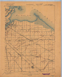
Maumee Bay, Ohio, USGS topographic map dated 1900.
Includes geographic coordinates (latitude and longitude). This topographic map is suitable for hiking, camping, and exploring, or framing it as a wall map.
Printed on-demand using high resolution imagery, on heavy weight and acid free paper, or alternatively on a variety of synthetic materials.
Topos available on paper, Waterproof, Poly, or Tyvek. Usually shipping rolled, unless combined with other folded maps in one order.
- Product Number: USGS-5321082
- Free digital map download (high-resolution, GeoPDF): Maumee Bay, Ohio (file size: 4 MB)
- Map Size: please refer to the dimensions of the GeoPDF map above
- Weight (paper map): ca. 55 grams
- Map Type: POD USGS Topographic Map
- Map Series: HTMC
- Map Verison: Historical
- Cell ID: 57277
- Scan ID: 516648
- Imprint Year: 1921
- Survey Year: 1899
- Datum: Unstated
- Map Projection: Unstated
- Map published by United States Geological Survey
- Map Language: English
- Scanner Resolution: 508 dpi
- Map Cell Name: Maumee Bay
- Grid size: 15 X 15 Minute
- Date on map: 1900
- Map Scale: 1:62500
- Geographical region: Ohio, United States
Neighboring Maps:
All neighboring USGS topo maps are available for sale online at a variety of scales.
Spatial coverage:
Topo map Maumee Bay, Ohio, covers the geographical area associated the following places:
- New Jerusalem (historical) - Walnut Hills Mobile Home Park - Elliston - Niles Beach - Ryan - Immergrun - Middleton (historical) - Booth - Latcha - East Gardens - Ironville - Woodville Gardens - Webb (historical) - Reno Beach - Crosswoods - Oregon - Turnberry Estates - Hille Farms - Sheldon (historical) - Cresceus Farms - Northwood - West Pointe - Bono - Curtice - Harbor View - Point Place - Deluxe Mobile Home Park - The Meadows - Cedar Creek - Park Du Langlade - Updyke Addition - Cummings (historical) - Blackberry Corner - South Shore Park - Wood Lake Mobile Home Park - Walbridge - Willow Beach - Millbury - Crane Creek Place - Cedar Creek Woods - Lindbergh Heights - Graytown - Dixon - Grodis Corner - Brighton Gardens - Aztec Subdivision - Vickers - Northcrest - Orchard View - Woodhurst - Clay Center - Indian Trail Estates - Johnsons Subdivision - Windemere Orchards - Eastpointe on the Mall - East Lawn - Wolf Creek Addition - Woodland Forest - Biltmore Gardens - Martin - Yondota - Trowbridge - Williston - Momeneetown - Forest Park - Lakemont Landing - Hayes Place - Moundview Park - Bieber - Genoa - Troy Villa Mobile Home Park - Mound View - Shore Acres - Lakeland
- Map Area ID: AREA41.7541.5-83.5-83.25
- Northwest corner Lat/Long code: USGSNW41.75-83.5
- Northeast corner Lat/Long code: USGSNE41.75-83.25
- Southwest corner Lat/Long code: USGSSW41.5-83.5
- Southeast corner Lat/Long code: USGSSE41.5-83.25
- Northern map edge Latitude: 41.75
- Southern map edge Latitude: 41.5
- Western map edge Longitude: -83.5
- Eastern map edge Longitude: -83.25


