
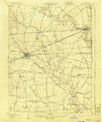
~ London OH topo map, 1:62500 scale, 15 X 15 Minute, Historical, 1907, updated 1940
London, Ohio, USGS topographic map dated 1907.
Includes geographic coordinates (latitude and longitude). This topographic map is suitable for hiking, camping, and exploring, or framing it as a wall map.
Printed on-demand using high resolution imagery, on heavy weight and acid free paper, or alternatively on a variety of synthetic materials.
Topos available on paper, Waterproof, Poly, or Tyvek. Usually shipping rolled, unless combined with other folded maps in one order.
- Product Number: USGS-5321034
- Free digital map download (high-resolution, GeoPDF): London, Ohio (file size: 5 MB)
- Map Size: please refer to the dimensions of the GeoPDF map above
- Weight (paper map): ca. 55 grams
- Map Type: POD USGS Topographic Map
- Map Series: HTMC
- Map Verison: Historical
- Cell ID: 56856
- Scan ID: 225631
- Imprint Year: 1940
- Visual Version Number: 2
- Survey Year: 1905
- Datum: NAD
- Map Projection: Polyconic
- Map published by United States Geological Survey
- Map Language: English
- Scanner Resolution: 600 dpi
- Map Cell Name: London
- Grid size: 15 X 15 Minute
- Date on map: 1907
- Map Scale: 1:62500
- Geographical region: Ohio, United States
Neighboring Maps:
All neighboring USGS topo maps are available for sale online at a variety of scales.
Spatial coverage:
Topo map London, Ohio, covers the geographical area associated the following places:
- Chrisman - Newport - Willows (historical) - Brooks Edge - Amherst Meadows - Big Plain - Nioga (historical) - London Terrace - Hyde Park - Chevington Place - Sheffield Commons - Green Meadows Mobile Home Park - Choctaw Lake - Gillivan - Kiousville - Tradersville - Carters (historical) - Roberts (historical) - Deer Creek Village (historical) - West Jefferson - Jefferson Lodge Mobile Home Park - Choctaw Lake Subdivision - Rupert - Summerford - McKendree - Wilson (historical) - Oakwood Acres - Lafayette - Antioch - London - Lilly Chapel - Madison Lake - Elmhurst - Hidden Creek At The Darby
- Map Area ID: AREA4039.75-83.5-83.25
- Northwest corner Lat/Long code: USGSNW40-83.5
- Northeast corner Lat/Long code: USGSNE40-83.25
- Southwest corner Lat/Long code: USGSSW39.75-83.5
- Southeast corner Lat/Long code: USGSSE39.75-83.25
- Northern map edge Latitude: 40
- Southern map edge Latitude: 39.75
- Western map edge Longitude: -83.5
- Eastern map edge Longitude: -83.25


