
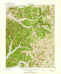
~ Laurelville OH topo map, 1:62500 scale, 15 X 15 Minute, Historical, 1910, updated 1962
Laurelville, Ohio, USGS topographic map dated 1910.
Includes geographic coordinates (latitude and longitude). This topographic map is suitable for hiking, camping, and exploring, or framing it as a wall map.
Printed on-demand using high resolution imagery, on heavy weight and acid free paper, or alternatively on a variety of synthetic materials.
Topos available on paper, Waterproof, Poly, or Tyvek. Usually shipping rolled, unless combined with other folded maps in one order.
- Product Number: USGS-5321010
- Free digital map download (high-resolution, GeoPDF): Laurelville, Ohio (file size: 11 MB)
- Map Size: please refer to the dimensions of the GeoPDF map above
- Weight (paper map): ca. 55 grams
- Map Type: POD USGS Topographic Map
- Map Series: HTMC
- Map Verison: Historical
- Cell ID: 56583
- Scan ID: 225555
- Imprint Year: 1962
- Woodland Tint: Yes
- Survey Year: 1910
- Datum: NAD27
- Map Projection: Polyconic
- Map published by United States Geological Survey
- Map Language: English
- Scanner Resolution: 600 dpi
- Map Cell Name: Laurelville
- Grid size: 15 X 15 Minute
- Date on map: 1910
- Map Scale: 1:62500
- Geographical region: Ohio, United States
Neighboring Maps:
All neighboring USGS topo maps are available for sale online at a variety of scales.
Spatial coverage:
Topo map Laurelville, Ohio, covers the geographical area associated the following places:
- Pursell (historical) - Reeds (historical) - Allensville - Eagle Mills - Stella - Cox (historical) - Adelphi - Apple - Rockhouse (historical) - Nancy (historical) - Cedar Grove - Jimtown - South Perry - Feightner (historical) - Laurelville - Goosetown (historical) - Royal - Cedar Falls (historical) - Point Pleasant (historical) - Gibisonville - Haynes - South Bloomingville - Ratcliffburg - Hue
- Map Area ID: AREA39.539.25-82.75-82.5
- Northwest corner Lat/Long code: USGSNW39.5-82.75
- Northeast corner Lat/Long code: USGSNE39.5-82.5
- Southwest corner Lat/Long code: USGSSW39.25-82.75
- Southeast corner Lat/Long code: USGSSE39.25-82.5
- Northern map edge Latitude: 39.5
- Southern map edge Latitude: 39.25
- Western map edge Longitude: -82.75
- Eastern map edge Longitude: -82.5


