
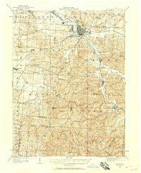
~ Lancaster OH topo map, 1:62500 scale, 15 X 15 Minute, Historical, 1907, updated 1958
Lancaster, Ohio, USGS topographic map dated 1907.
Includes geographic coordinates (latitude and longitude). This topographic map is suitable for hiking, camping, and exploring, or framing it as a wall map.
Printed on-demand using high resolution imagery, on heavy weight and acid free paper, or alternatively on a variety of synthetic materials.
Topos available on paper, Waterproof, Poly, or Tyvek. Usually shipping rolled, unless combined with other folded maps in one order.
- Product Number: USGS-5321004
- Free digital map download (high-resolution, GeoPDF): Lancaster, Ohio (file size: 10 MB)
- Map Size: please refer to the dimensions of the GeoPDF map above
- Weight (paper map): ca. 55 grams
- Map Type: POD USGS Topographic Map
- Map Series: HTMC
- Map Verison: Historical
- Cell ID: 56530
- Scan ID: 225533
- Imprint Year: 1958
- Survey Year: 1907
- Datum: NAD27
- Map Projection: Polyconic
- Map published by United States Geological Survey
- Map Language: English
- Scanner Resolution: 600 dpi
- Map Cell Name: Lancaster
- Grid size: 15 X 15 Minute
- Date on map: 1907
- Map Scale: 1:62500
- Geographical region: Ohio, United States
Neighboring Maps:
All neighboring USGS topo maps are available for sale online at a variety of scales.
Spatial coverage:
Topo map Lancaster, Ohio, covers the geographical area associated the following places:
- Blackburn (historical) - Carpenters Addition - Yogi's Mobile Home Park - Whites - Sugar Grove - Pine Grove (historical) - Sandstone (historical) - Brookdale Mobile Home Park - Colfax - Blue Valley Acres - Rock Mill - Pleasant Hill - Wacker Heights - Hooker - Drinkle - Taylor Mobile Home Park - Lancaster Mobile Estates - Hamburg - Mound Crossing - Rustic Ridge Manufactured Housing Community - Tarhe Town (historical) - Buena Vista - Colony Village Mobile Home Park - Clearport - Lancaster - Pine Lake Estates - Delmont - Revenge - Rest-over Trailer Park - Wesley Chapel - Horns Mill - Rockbridge - Amanda - Colonial Estates
- Map Area ID: AREA39.7539.5-82.75-82.5
- Northwest corner Lat/Long code: USGSNW39.75-82.75
- Northeast corner Lat/Long code: USGSNE39.75-82.5
- Southwest corner Lat/Long code: USGSSW39.5-82.75
- Southeast corner Lat/Long code: USGSSE39.5-82.5
- Northern map edge Latitude: 39.75
- Southern map edge Latitude: 39.5
- Western map edge Longitude: -82.75
- Eastern map edge Longitude: -82.5


