
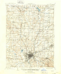
~ Canton OH topo map, 1:62500 scale, 15 X 15 Minute, Historical, 1903, updated 1950
Canton, Ohio, USGS topographic map dated 1903.
Includes geographic coordinates (latitude and longitude). This topographic map is suitable for hiking, camping, and exploring, or framing it as a wall map.
Printed on-demand using high resolution imagery, on heavy weight and acid free paper, or alternatively on a variety of synthetic materials.
Topos available on paper, Waterproof, Poly, or Tyvek. Usually shipping rolled, unless combined with other folded maps in one order.
- Product Number: USGS-5320728
- Free digital map download (high-resolution, GeoPDF): Canton, Ohio (file size: 7 MB)
- Map Size: please refer to the dimensions of the GeoPDF map above
- Weight (paper map): ca. 55 grams
- Map Type: POD USGS Topographic Map
- Map Series: HTMC
- Map Verison: Historical
- Cell ID: 52114
- Scan ID: 224313
- Imprint Year: 1950
- Survey Year: 1901
- Datum: NAD
- Map Projection: Polyconic
- Map published by United States Geological Survey
- Map Language: English
- Scanner Resolution: 600 dpi
- Map Cell Name: Canton
- Grid size: 15 X 15 Minute
- Date on map: 1903
- Map Scale: 1:62500
- Geographical region: Ohio, United States
Neighboring Maps:
All neighboring USGS topo maps are available for sale online at a variety of scales.
Spatial coverage:
Topo map Canton, Ohio, covers the geographical area associated the following places:
- Brookwood Estates - Congress Lake (historical) - Canton Gardens - Terrace Mobile Park - Orchard Heights - Monterey Heights - Mayfair Heights - Sweetbriar - Kungle Heights - Bishop Meadows - Charleston Place - Arlington Knolls - Royal Mobile Park - Carie Hill Estates - Edmeyer Park - Kimberly Valley - West Manor - Whispering Oaks - Forest Lake Estates - Lake View Heights - Greenfield Farms - Ridgedale - Green - Banker Heights - Greentown - Green Highlands - Uniontown - Fairhope - Myersville - High Tower Estates - Meyers Lake - Sun Valley Mobile Home Park - Mishler - Deluxe Mobile Home Park - Lakeview Terrace - Belvidere - Whittier Park - Anchor Mobile Home Park - Pleasant View Village - Pressler Heights - Stratford Green At Mayfair - Cairo - Cloverdale - Lakeview Heights - Grey Ridge Estates - Colonial Hills - Crystal Park - Skyline Hills - Hills and Dales - Rolling Greens Estates - Richmond Mobile Home Park - Villages At Meadow Wood - Mayfield Mobile Home Park - North Canton - Oval City - Oak Manor - Paddington Woods - Melody Mobile Home Park - Mount Marie Heights - Lawnfield Estates - East Orchard - Avondale - Lake Slagle - Springhill - McDonaldsville - East Canton - Pleasant View - Parkridge - Bramblecrest - Fox Ridge Estates - Mount Pleasant - Raintree Estates - Hidden Trail Estates - Hyde Park - North Market Mobile Home Park - Grove Mill - Lynn Center Park - The Knolls - Tower Terrace - Lindale Heights - Westland Park - Gambrinus - Fulton Heights - Crescent Gardens - Park Ridge Estates - Lakeside Heights - Lakes Of Green - Whipple Heights - Bingo Estates - Robinwood Estates - Harter Heights - Marks (historical) - Maces Mobile Estates - Rolling Greens - Richville - Park Creek Estates - Thunderbird Terrace - Willow Brook Heights - South Haven Mobile Park - Westview
- Map Area ID: AREA4140.75-81.5-81.25
- Northwest corner Lat/Long code: USGSNW41-81.5
- Northeast corner Lat/Long code: USGSNE41-81.25
- Southwest corner Lat/Long code: USGSSW40.75-81.5
- Southeast corner Lat/Long code: USGSSE40.75-81.25
- Northern map edge Latitude: 41
- Southern map edge Latitude: 40.75
- Western map edge Longitude: -81.5
- Eastern map edge Longitude: -81.25


