
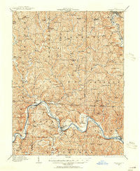
~ Caldwell OH topo map, 1:62500 scale, 15 X 15 Minute, Historical, 1909, updated 1956
Caldwell, Ohio, USGS topographic map dated 1909.
Includes geographic coordinates (latitude and longitude). This topographic map is suitable for hiking, camping, and exploring, or framing it as a wall map.
Printed on-demand using high resolution imagery, on heavy weight and acid free paper, or alternatively on a variety of synthetic materials.
Topos available on paper, Waterproof, Poly, or Tyvek. Usually shipping rolled, unless combined with other folded maps in one order.
- Product Number: USGS-5320714
- Free digital map download (high-resolution, GeoPDF): Caldwell, Ohio (file size: 12 MB)
- Map Size: please refer to the dimensions of the GeoPDF map above
- Weight (paper map): ca. 55 grams
- Map Type: POD USGS Topographic Map
- Map Series: HTMC
- Map Verison: Historical
- Cell ID: 72714
- Scan ID: 224265
- Imprint Year: 1956
- Survey Year: 1909
- Datum: NAD
- Map Projection: Polyconic
- Map published by United States Geological Survey
- Map Language: English
- Scanner Resolution: 600 dpi
- Map Cell Name: Caldwell
- Grid size: 15 X 15 Minute
- Date on map: 1909
- Map Scale: 1:62500
- Geographical region: Ohio, United States
Neighboring Maps:
All neighboring USGS topo maps are available for sale online at a variety of scales.
Spatial coverage:
Topo map Caldwell, Ohio, covers the geographical area associated the following places:
- Waterford - Lowell - Brokaw - Rich Valley - Three Forks - Swift - Hackney - Hayward - Mill Grove - Beverly - Centerville - Keith - Relief - Luke Chute - Roxbury - Bristol - Sharon - Olive Green - Brill (historical) - Caldwell - Cabinville (historical) - Unionville - Coal Run - Seeleyburg (historical) - Otho (historical) - Dungannon - Upper Lowell - Dudley - Equity - Ludlow - Center Bend - Reinersville - Clifton - Moscow Mills - Lowell Trailer Park - Hillview Mobile Home Park - Beckett
- Map Area ID: AREA39.7539.5-81.75-81.5
- Northwest corner Lat/Long code: USGSNW39.75-81.75
- Northeast corner Lat/Long code: USGSNE39.75-81.5
- Southwest corner Lat/Long code: USGSSW39.5-81.75
- Southeast corner Lat/Long code: USGSSE39.5-81.5
- Northern map edge Latitude: 39.75
- Southern map edge Latitude: 39.5
- Western map edge Longitude: -81.75
- Eastern map edge Longitude: -81.5


