
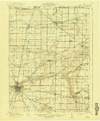
~ Bucyrus OH topo map, 1:62500 scale, 15 X 15 Minute, Historical, 1915, updated 1940
Bucyrus, Ohio, USGS topographic map dated 1915.
Includes geographic coordinates (latitude and longitude). This topographic map is suitable for hiking, camping, and exploring, or framing it as a wall map.
Printed on-demand using high resolution imagery, on heavy weight and acid free paper, or alternatively on a variety of synthetic materials.
Topos available on paper, Waterproof, Poly, or Tyvek. Usually shipping rolled, unless combined with other folded maps in one order.
- Product Number: USGS-5320704
- Free digital map download (high-resolution, GeoPDF): Bucyrus, Ohio (file size: 6 MB)
- Map Size: please refer to the dimensions of the GeoPDF map above
- Weight (paper map): ca. 55 grams
- Map Type: POD USGS Topographic Map
- Map Series: HTMC
- Map Verison: Historical
- Cell ID: 51886
- Scan ID: 224218
- Imprint Year: 1940
- Survey Year: 1913
- Datum: Unstated
- Map Projection: Polyconic
- Map published by United States Geological Survey
- Map Language: English
- Scanner Resolution: 600 dpi
- Map Cell Name: Bucyrus
- Grid size: 15 X 15 Minute
- Date on map: 1915
- Map Scale: 1:62500
- Geographical region: Ohio, United States
Neighboring Maps:
All neighboring USGS topo maps are available for sale online at a variety of scales.
Spatial coverage:
Topo map Bucyrus, Ohio, covers the geographical area associated the following places:
- Mechanicsburg - Middletown - Linden Park - Ridgeton - New Washington - Waterford Glen - Hill Street Mobile Home Park - Carrothers - Chatfield - River Edge Mobile Park - North Robinson - Tiro - Sulphur Springs - Dekalb - Northwood Estates - Biddle (historical) - Waynesburg - Mcfarland's Mobile Home Park - Bucyrus - West Liberty - Maple Grove Park - North Auburn - Brandywine - Leesville - Fauser (historical) - Olentangy
- Map Area ID: AREA4140.75-83-82.75
- Northwest corner Lat/Long code: USGSNW41-83
- Northeast corner Lat/Long code: USGSNE41-82.75
- Southwest corner Lat/Long code: USGSSW40.75-83
- Southeast corner Lat/Long code: USGSSE40.75-82.75
- Northern map edge Latitude: 41
- Southern map edge Latitude: 40.75
- Western map edge Longitude: -83
- Eastern map edge Longitude: -82.75


