
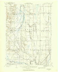
~ Bristolville OH topo map, 1:62500 scale, 15 X 15 Minute, Historical, 1905, updated 1956
Bristolville, Ohio, USGS topographic map dated 1905.
Includes geographic coordinates (latitude and longitude). This topographic map is suitable for hiking, camping, and exploring, or framing it as a wall map.
Printed on-demand using high resolution imagery, on heavy weight and acid free paper, or alternatively on a variety of synthetic materials.
Topos available on paper, Waterproof, Poly, or Tyvek. Usually shipping rolled, unless combined with other folded maps in one order.
- Product Number: USGS-5320698
- Free digital map download (high-resolution, GeoPDF): Bristolville, Ohio (file size: 5 MB)
- Map Size: please refer to the dimensions of the GeoPDF map above
- Weight (paper map): ca. 55 grams
- Map Type: POD USGS Topographic Map
- Map Series: HTMC
- Map Verison: Historical
- Cell ID: 51798
- Scan ID: 224191
- Imprint Year: 1956
- Survey Year: 1905
- Datum: NAD27
- Map Projection: Polyconic
- Map published by United States Geological Survey
- Map Language: English
- Scanner Resolution: 600 dpi
- Map Cell Name: Bristolville
- Grid size: 15 X 15 Minute
- Date on map: 1905
- Map Scale: 1:62500
- Geographical region: Ohio, United States
Neighboring Maps:
All neighboring USGS topo maps are available for sale online at a variety of scales.
Spatial coverage:
Topo map Bristolville, Ohio, covers the geographical area associated the following places:
- State Road - Wilhelm Corner - Clover Hill - Bristolville - Greene Center - West Farmington - Mobile Haven Park - Deacon Creek Corner - Delightful - Forest Grove Mobile Home Park - Farmington - Southington - Pleasant Park Mobile Home Park - Champion - North Bloomfield - Stroups - Shihold - Klondike - North Bristol - Spokane - West Mecca - Mesopotamia - Shady Lane Mobile Home Park - Hardscrabble - Wassie (historical) - Herner Corners - East Farmington - Brookside Park - Evergreen Mobile Home Court - Phalanx - Morgandale - Oakfield - Brown Corner - Wildare - Lockwood - Hoagland Corner - Lakeview Mobile Home Park - Southington Estates
- Map Area ID: AREA41.541.25-81-80.75
- Northwest corner Lat/Long code: USGSNW41.5-81
- Northeast corner Lat/Long code: USGSNE41.5-80.75
- Southwest corner Lat/Long code: USGSSW41.25-81
- Southeast corner Lat/Long code: USGSSE41.25-80.75
- Northern map edge Latitude: 41.5
- Southern map edge Latitude: 41.25
- Western map edge Longitude: -81
- Eastern map edge Longitude: -80.75


