
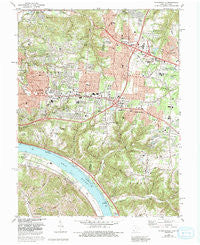
~ Withamsville OH topo map, 1:24000 scale, 7.5 X 7.5 Minute, Historical, 1983, updated 1992
Withamsville, Ohio, USGS topographic map dated 1983.
Includes geographic coordinates (latitude and longitude). This topographic map is suitable for hiking, camping, and exploring, or framing it as a wall map.
Printed on-demand using high resolution imagery, on heavy weight and acid free paper, or alternatively on a variety of synthetic materials.
Topos available on paper, Waterproof, Poly, or Tyvek. Usually shipping rolled, unless combined with other folded maps in one order.
- Product Number: USGS-5320454
- Free digital map download (high-resolution, GeoPDF): Withamsville, Ohio (file size: 17 MB)
- Map Size: please refer to the dimensions of the GeoPDF map above
- Weight (paper map): ca. 55 grams
- Map Type: POD USGS Topographic Map
- Map Series: HTMC
- Map Verison: Historical
- Cell ID: 49602
- Scan ID: 228327
- Imprint Year: 1992
- Woodland Tint: Yes
- Aerial Photo Year: 1988
- Edit Year: 1992
- Field Check Year: 1977
- Datum: NAD27
- Map Projection: Polyconic
- Map published by United States Geological Survey
- Map Language: English
- Scanner Resolution: 600 dpi
- Map Cell Name: Withamsville
- Grid size: 7.5 X 7.5 Minute
- Date on map: 1983
- Map Scale: 1:24000
- Geographical region: Ohio, United States
Neighboring Maps:
All neighboring USGS topo maps are available for sale online at a variety of scales.
Spatial coverage:
Topo map Withamsville, Ohio, covers the geographical area associated the following places:
- Summerside Estates - Glen Ridge Acres - Paddison Hills - Spann (historical) - Fruit Hill - Am-Beth Acres - Locust Corner - New Palestine - Ross - Viking Village - Eightmile - Lawyerdale Estates - Mount Summit - Home (historical) - Hill Craft Acres - Melbourne - Clough Heights - Asbury - Glen Este - Withamsville - Mount Carmel Heights - Watch Hill - Huntcrest Acres - Sherwood Village - Fernell Heights - Ninemile - Sherwood - Newtown - Britney Acres - Merwin - Mount Forest Trails - Summerside - Valley View Heights - Mount Carmel - Cherry Grove - Vermona - Camp Springs - Dry Run - Alpine Terrace - Forest Hills Estates - Ellenora - Forestville - Tobasco
- Map Area ID: AREA39.12539-84.375-84.25
- Northwest corner Lat/Long code: USGSNW39.125-84.375
- Northeast corner Lat/Long code: USGSNE39.125-84.25
- Southwest corner Lat/Long code: USGSSW39-84.375
- Southeast corner Lat/Long code: USGSSE39-84.25
- Northern map edge Latitude: 39.125
- Southern map edge Latitude: 39
- Western map edge Longitude: -84.375
- Eastern map edge Longitude: -84.25


