
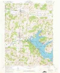
~ Senecaville OH topo map, 1:24000 scale, 7.5 X 7.5 Minute, Historical, 1961, updated 1972
Senecaville, Ohio, USGS topographic map dated 1961.
Includes geographic coordinates (latitude and longitude). This topographic map is suitable for hiking, camping, and exploring, or framing it as a wall map.
Printed on-demand using high resolution imagery, on heavy weight and acid free paper, or alternatively on a variety of synthetic materials.
Topos available on paper, Waterproof, Poly, or Tyvek. Usually shipping rolled, unless combined with other folded maps in one order.
- Product Number: USGS-5319362
- Free digital map download (high-resolution, GeoPDF): Senecaville, Ohio (file size: 11 MB)
- Map Size: please refer to the dimensions of the GeoPDF map above
- Weight (paper map): ca. 55 grams
- Map Type: POD USGS Topographic Map
- Map Series: HTMC
- Map Verison: Historical
- Cell ID: 40578
- Scan ID: 226952
- Imprint Year: 1972
- Woodland Tint: Yes
- Aerial Photo Year: 1960
- Field Check Year: 1961
- Datum: NAD27
- Map Projection: Polyconic
- Map published by United States Geological Survey
- Map Language: English
- Scanner Resolution: 600 dpi
- Map Cell Name: Senecaville
- Grid size: 7.5 X 7.5 Minute
- Date on map: 1961
- Map Scale: 1:24000
- Geographical region: Ohio, United States
Neighboring Maps:
All neighboring USGS topo maps are available for sale online at a variety of scales.
Spatial coverage:
Topo map Senecaville, Ohio, covers the geographical area associated the following places:
- Hickory Grove Cottage Area - Walhonding - Kennonsburg - Chaseville - Noble Cottage Area - Lakeview - Kings Mine - West Shore Cottage Area - Mud Run - Greenwood - New Gottingen - Echo Point - Lashley - Chestnut Grove Cottage Area - Duch Addition - East Shore Cottage Area - Lore City - Seneca Lake Estates - Gibson - Rose Addition - Blacktop - Senecaville
- Map Area ID: AREA4039.875-81.5-81.375
- Northwest corner Lat/Long code: USGSNW40-81.5
- Northeast corner Lat/Long code: USGSNE40-81.375
- Southwest corner Lat/Long code: USGSSW39.875-81.5
- Southeast corner Lat/Long code: USGSSE39.875-81.375
- Northern map edge Latitude: 40
- Southern map edge Latitude: 39.875
- Western map edge Longitude: -81.5
- Eastern map edge Longitude: -81.375


