
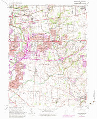
~ Reynoldsburg OH topo map, 1:24000 scale, 7.5 X 7.5 Minute, Historical, 1964, updated 1974
Reynoldsburg, Ohio, USGS topographic map dated 1964.
Includes geographic coordinates (latitude and longitude). This topographic map is suitable for hiking, camping, and exploring, or framing it as a wall map.
Printed on-demand using high resolution imagery, on heavy weight and acid free paper, or alternatively on a variety of synthetic materials.
Topos available on paper, Waterproof, Poly, or Tyvek. Usually shipping rolled, unless combined with other folded maps in one order.
- Product Number: USGS-5319110
- Free digital map download (high-resolution, GeoPDF): Reynoldsburg, Ohio (file size: 11 MB)
- Map Size: please refer to the dimensions of the GeoPDF map above
- Weight (paper map): ca. 55 grams
- Map Type: POD USGS Topographic Map
- Map Series: HTMC
- Map Verison: Historical
- Cell ID: 37714
- Scan ID: 227290
- Imprint Year: 1974
- Woodland Tint: Yes
- Visual Version Number: 2
- Photo Revision Year: 1973
- Aerial Photo Year: 1973
- Edit Year: 1964
- Survey Year: 1955
- Datum: NAD27
- Map Projection: Polyconic
- Map published by United States Geological Survey
- Map Language: English
- Scanner Resolution: 600 dpi
- Map Cell Name: Reynoldsburg
- Grid size: 7.5 X 7.5 Minute
- Date on map: 1964
- Map Scale: 1:24000
- Geographical region: Ohio, United States
Neighboring Maps:
All neighboring USGS topo maps are available for sale online at a variety of scales.
Spatial coverage:
Topo map Reynoldsburg, Ohio, covers the geographical area associated the following places:
- Waggoner Woods - Idlewood Manor - Countryview Village - White Oak Park - Motts Place - Taylor Station - Brice Meadows - Rose Hill Heights - Bedford Place - Waggoner Park - Pickerington - Village At Shannon Green - Summit Station - Stonehill - Reynoldsburg - Longwood - Blacklick - Dorchester Green - Cobbleton Grove - Chelsea Glen - Essex Place - Abbie Trails - Brookside Park - Brice - Blacklick Ridge - Hummell Grove - Blacklick Estates - Kingswood Farms - Briarcliff - Kensington Glen - Crawford Farms
- Map Area ID: AREA4039.875-82.875-82.75
- Northwest corner Lat/Long code: USGSNW40-82.875
- Northeast corner Lat/Long code: USGSNE40-82.75
- Southwest corner Lat/Long code: USGSSW39.875-82.875
- Southeast corner Lat/Long code: USGSSE39.875-82.75
- Northern map edge Latitude: 40
- Southern map edge Latitude: 39.875
- Western map edge Longitude: -82.875
- Eastern map edge Longitude: -82.75


