
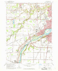
~ Maumee OH topo map, 1:24000 scale, 7.5 X 7.5 Minute, Historical, 1964, updated 1969
Maumee, Ohio, USGS topographic map dated 1964.
Includes geographic coordinates (latitude and longitude). This topographic map is suitable for hiking, camping, and exploring, or framing it as a wall map.
Printed on-demand using high resolution imagery, on heavy weight and acid free paper, or alternatively on a variety of synthetic materials.
Topos available on paper, Waterproof, Poly, or Tyvek. Usually shipping rolled, unless combined with other folded maps in one order.
- Product Number: USGS-5317846
- Free digital map download (high-resolution, GeoPDF): Maumee, Ohio (file size: 9 MB)
- Map Size: please refer to the dimensions of the GeoPDF map above
- Weight (paper map): ca. 55 grams
- Map Type: POD USGS Topographic Map
- Map Series: HTMC
- Map Verison: Historical
- Cell ID: 28053
- Scan ID: 227769
- Imprint Year: 1969
- Woodland Tint: Yes
- Edit Year: 1964
- Survey Year: 1935
- Datum: NAD27
- Map Projection: Polyconic
- Map published by United States Geological Survey
- Map Language: English
- Scanner Resolution: 600 dpi
- Map Cell Name: Maumee
- Grid size: 7.5 X 7.5 Minute
- Date on map: 1964
- Map Scale: 1:24000
- Geographical region: Ohio, United States
Neighboring Maps:
All neighboring USGS topo maps are available for sale online at a variety of scales.
Spatial coverage:
Topo map Maumee, Ohio, covers the geographical area associated the following places:
- Sandburr Corners - McKinley Woods - Hulls Crossing - Kettle Run - Holland - Business Corner - Indian Meadows - Riverford - Fort Meigs Place - Willowbend - The Estates of Fort Meigs - Johnston Corners - D'Arcy Estates - Homewood - Carrington Woods - Monclova - Perrysburg Heights - Presque Isle (historical) - Rivercrest - Waterville - Spring Valley - Perrysburg - Roachton - Southview Estates Mobile Home Park - Maumee - Meigs on the River - Crandenbrook
- Map Area ID: AREA41.62541.5-83.75-83.625
- Northwest corner Lat/Long code: USGSNW41.625-83.75
- Northeast corner Lat/Long code: USGSNE41.625-83.625
- Southwest corner Lat/Long code: USGSSW41.5-83.75
- Southeast corner Lat/Long code: USGSSE41.5-83.625
- Northern map edge Latitude: 41.625
- Southern map edge Latitude: 41.5
- Western map edge Longitude: -83.75
- Eastern map edge Longitude: -83.625


