
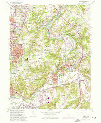
~ Madeira OH topo map, 1:24000 scale, 7.5 X 7.5 Minute, Historical, 1961, updated 1975
Madeira, Ohio, USGS topographic map dated 1961.
Includes geographic coordinates (latitude and longitude). This topographic map is suitable for hiking, camping, and exploring, or framing it as a wall map.
Printed on-demand using high resolution imagery, on heavy weight and acid free paper, or alternatively on a variety of synthetic materials.
Topos available on paper, Waterproof, Poly, or Tyvek. Usually shipping rolled, unless combined with other folded maps in one order.
- Product Number: USGS-5317684
- Free digital map download (high-resolution, GeoPDF): Madeira, Ohio (file size: 15 MB)
- Map Size: please refer to the dimensions of the GeoPDF map above
- Weight (paper map): ca. 55 grams
- Map Type: POD USGS Topographic Map
- Map Series: HTMC
- Map Verison: Historical
- Cell ID: 27161
- Scan ID: 225690
- Imprint Year: 1975
- Woodland Tint: Yes
- Photo Revision Year: 1974
- Aerial Photo Year: 1974
- Edit Year: 1961
- Survey Year: 1953
- Datum: NAD27
- Map Projection: Polyconic
- Map published by United States Geological Survey
- Map Language: English
- Scanner Resolution: 600 dpi
- Map Cell Name: Madeira
- Grid size: 7.5 X 7.5 Minute
- Date on map: 1961
- Map Scale: 1:24000
- Geographical region: Ohio, United States
Neighboring Maps:
All neighboring USGS topo maps are available for sale online at a variety of scales.
Spatial coverage:
Topo map Madeira, Ohio, covers the geographical area associated the following places:
- Shademoore - Fairwind Acres - Al Bar Meadows - Barwyn Acres - Clertoma - Kenwood - Miami Grove - Jones Farm - The Village of Indian Hill - Madeira - Raiders Run - Plainville - Montgomery - Milford - Indian Hill - Epworth Heights - Ancor - Allandale (historical) - Montgomery Heights - Foxhunter Lane - Terrace Park - Avoca Park - Top-of-the-Ridge - Remington - South Milford - Camp Dennison - Beverly Hills - Branch Hill - Symmes - Miamiville - Glenwood (historical) - Mariemont - Romohr Acres - Sundale - Beechwood (historical) - Indian Knolls - Gravelotte (historical) - Indianview - The Highlands - South Clippinger
- Map Area ID: AREA39.2539.125-84.375-84.25
- Northwest corner Lat/Long code: USGSNW39.25-84.375
- Northeast corner Lat/Long code: USGSNE39.25-84.25
- Southwest corner Lat/Long code: USGSSW39.125-84.375
- Southeast corner Lat/Long code: USGSSE39.125-84.25
- Northern map edge Latitude: 39.25
- Southern map edge Latitude: 39.125
- Western map edge Longitude: -84.375
- Eastern map edge Longitude: -84.25


