
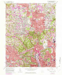
~ Cincinnati West OH topo map, 1:24000 scale, 7.5 X 7.5 Minute, Historical, 1961, updated 1982
Cincinnati West, Ohio, USGS topographic map dated 1961.
Includes geographic coordinates (latitude and longitude). This topographic map is suitable for hiking, camping, and exploring, or framing it as a wall map.
Printed on-demand using high resolution imagery, on heavy weight and acid free paper, or alternatively on a variety of synthetic materials.
Topos available on paper, Waterproof, Poly, or Tyvek. Usually shipping rolled, unless combined with other folded maps in one order.
- Product Number: USGS-5315808
- Free digital map download (high-resolution, GeoPDF): Cincinnati West, Ohio (file size: 19 MB)
- Map Size: please refer to the dimensions of the GeoPDF map above
- Weight (paper map): ca. 55 grams
- Map Type: POD USGS Topographic Map
- Map Series: HTMC
- Map Verison: Historical
- Cell ID: 69654
- Scan ID: 224440
- Imprint Year: 1982
- Woodland Tint: Yes
- Photo Revision Year: 1981
- Aerial Photo Year: 1979
- Edit Year: 1981
- Field Check Year: 1953
- Datum: NAD27
- Map Projection: Polyconic
- Map published by United States Geological Survey
- Map Language: English
- Scanner Resolution: 600 dpi
- Map Cell Name: Cincinnati West
- Grid size: 7.5 X 7.5 Minute
- Date on map: 1961
- Map Scale: 1:24000
- Geographical region: Ohio, United States
Neighboring Maps:
All neighboring USGS topo maps are available for sale online at a variety of scales.
Spatial coverage:
Topo map Cincinnati West, Ohio, covers the geographical area associated the following places:
- Hollywood Estates - Skyline Acres - Lynnview - Autumn Acres - Ivorydale Junction - Teakwood Acres - Marlain Acres - English Woods - Cheviot - White Oak Meadows - Barnesburg - Chesswood Acres - Wildbrook Acres - Winton Place - North College Hill - Compton Park - Finneytown - Clifton - College Hill - Colerain Heights - Oakdale - North Hills Estates - White Oak - Galaxy Acres - Wardwood Acres - Mount Airy - Losantville Triangle - Fox Acres - Crestwood Acres - Corryville - LaFeuille Terrace - Saint Peter - Groesbeck - Dornbusch - Summit - Cyclorama Heights - Spring Meadows - Greenfield Village - Northbrook - Fairmount - South Fairmount - Westwood - Wintondale - Cumminsville - Mount Airy Center - Golfway Acres - Camp Washington - Knowltons Corner - Pleasant Hills - Werk Place - Winton Terrace - Rohs Hill - Saint Jacobs - Monfort Heights - Clifton Heights - Mount Healthy - Brentwood
- Map Area ID: AREA39.2539.125-84.625-84.5
- Northwest corner Lat/Long code: USGSNW39.25-84.625
- Northeast corner Lat/Long code: USGSNE39.25-84.5
- Southwest corner Lat/Long code: USGSSW39.125-84.625
- Southeast corner Lat/Long code: USGSSE39.125-84.5
- Northern map edge Latitude: 39.25
- Southern map edge Latitude: 39.125
- Western map edge Longitude: -84.625
- Eastern map edge Longitude: -84.5


