
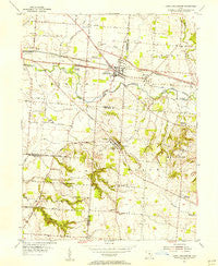
~ Canal Winchester OH topo map, 1:24000 scale, 7.5 X 7.5 Minute, Historical, 1955, updated 1956
Canal Winchester, Ohio, USGS topographic map dated 1955.
Includes geographic coordinates (latitude and longitude). This topographic map is suitable for hiking, camping, and exploring, or framing it as a wall map.
Printed on-demand using high resolution imagery, on heavy weight and acid free paper, or alternatively on a variety of synthetic materials.
Topos available on paper, Waterproof, Poly, or Tyvek. Usually shipping rolled, unless combined with other folded maps in one order.
- Product Number: USGS-5315560
- Free digital map download (high-resolution, GeoPDF): Canal Winchester, Ohio (file size: 9 MB)
- Map Size: please refer to the dimensions of the GeoPDF map above
- Weight (paper map): ca. 55 grams
- Map Type: POD USGS Topographic Map
- Map Series: HTMC
- Map Verison: Historical
- Cell ID: 69537
- Scan ID: 224292
- Imprint Year: 1956
- Woodland Tint: Yes
- Aerial Photo Year: 1953
- Field Check Year: 1955
- Datum: NAD27
- Map Projection: Polyconic
- Map published by United States Geological Survey
- Map Language: English
- Scanner Resolution: 600 dpi
- Map Cell Name: Canal Winchester
- Grid size: 7.5 X 7.5 Minute
- Date on map: 1955
- Map Scale: 1:24000
- Geographical region: Ohio, United States
Neighboring Maps:
All neighboring USGS topo maps are available for sale online at a variety of scales.
Spatial coverage:
Topo map Canal Winchester, Ohio, covers the geographical area associated the following places:
- Slate Ridge Estates - Marcy - Woodstream - Winchester Lakes - The Villages At Winchester - Waterloo - Washington Knoll - Beckley Addition - Greencastle - Fairfield Farms - Meadows At Winchester - Winchester Trace - Canal Winchester - Winchester Highlands - Slough - Winchester Park Addition - Lehman Meadows - Cedar Creek - Chester Heights - Kramers Addition - Jefferson - Lombardy Heights - Bixford Green - Lithopolis - Village At Schirm Farms - Gender Park - Villas At Charleston Lake - Greensview Villas - Lehman Estates
- Map Area ID: AREA39.87539.75-82.875-82.75
- Northwest corner Lat/Long code: USGSNW39.875-82.875
- Northeast corner Lat/Long code: USGSNE39.875-82.75
- Southwest corner Lat/Long code: USGSSW39.75-82.875
- Southeast corner Lat/Long code: USGSSE39.75-82.75
- Northern map edge Latitude: 39.875
- Southern map edge Latitude: 39.75
- Western map edge Longitude: -82.875
- Eastern map edge Longitude: -82.75


