
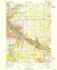
~ Campbell OH topo map, 1:24000 scale, 7.5 X 7.5 Minute, Historical, 1951, updated 1953
Campbell, Ohio, USGS topographic map dated 1951.
Includes geographic coordinates (latitude and longitude). This topographic map is suitable for hiking, camping, and exploring, or framing it as a wall map.
Printed on-demand using high resolution imagery, on heavy weight and acid free paper, or alternatively on a variety of synthetic materials.
Topos available on paper, Waterproof, Poly, or Tyvek. Usually shipping rolled, unless combined with other folded maps in one order.
- Product Number: USGS-5315542
- Free digital map download (high-resolution, GeoPDF): Campbell, Ohio (file size: 12 MB)
- Map Size: please refer to the dimensions of the GeoPDF map above
- Weight (paper map): ca. 55 grams
- Map Type: POD USGS Topographic Map
- Map Series: HTMC
- Map Verison: Historical
- Cell ID: 6946
- Scan ID: 224283
- Imprint Year: 1953
- Woodland Tint: Yes
- Aerial Photo Year: 1950
- Survey Year: 1951
- Datum: NAD27
- Map Projection: Polyconic
- Map published by United States Geological Survey
- Map Language: English
- Scanner Resolution: 600 dpi
- Map Cell Name: Campbell
- Grid size: 7.5 X 7.5 Minute
- Date on map: 1951
- Map Scale: 1:24000
- Geographical region: Ohio, United States
Neighboring Maps:
All neighboring USGS topo maps are available for sale online at a variety of scales.
Spatial coverage:
Topo map Campbell, Ohio, covers the geographical area associated the following places:
- Newport (historical) - Lowellville - Campbell - Struthers - Haselton - Crab Creek Junction - Coitsville Center - Poland - Fitch - New Bedford - Poland Center - Thorn Hill - King's Mobile Home Park - Geography Hall - Villa Maria - Scienceville
- Map Area ID: AREA41.12541-80.625-80.5
- Northwest corner Lat/Long code: USGSNW41.125-80.625
- Northeast corner Lat/Long code: USGSNE41.125-80.5
- Southwest corner Lat/Long code: USGSSW41-80.625
- Southeast corner Lat/Long code: USGSSE41-80.5
- Northern map edge Latitude: 41.125
- Southern map edge Latitude: 41
- Western map edge Longitude: -80.625
- Eastern map edge Longitude: -80.5


