
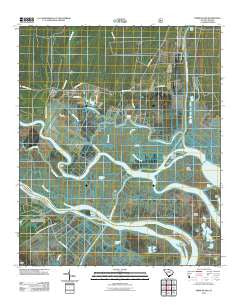
~ Minim Island SC topo map, 1:24000 scale, 7.5 X 7.5 Minute, Historical, 2011
Minim Island, South Carolina, USGS topographic map dated 2011.
Includes geographic coordinates (latitude and longitude). This topographic map is suitable for hiking, camping, and exploring, or framing it as a wall map.
Printed on-demand using high resolution imagery, on heavy weight and acid free paper, or alternatively on a variety of synthetic materials.
Topos available on paper, Waterproof, Poly, or Tyvek. Usually shipping rolled, unless combined with other folded maps in one order.
- Product Number: USGS-5311324
- Free digital map download (high-resolution, GeoPDF): Minim Island, South Carolina (file size: 20 MB)
- Map Size: please refer to the dimensions of the GeoPDF map above
- Weight (paper map): ca. 55 grams
- Map Type: POD USGS Topographic Map
- Map Series: US Topo
- Map Verison: Historical
- Cell ID: 29549
- Datum: North American Datum of 1983
- Map Projection: Transverse Mercator
- Map Cell Name: Minim Island
- Grid size: 7.5 X 7.5 Minute
- Date on map: 2011
- Map Scale: 1:24000
- Geographical region: South Carolina, United States
Neighboring Maps:
All neighboring USGS topo maps are available for sale online at a variety of scales.
Spatial coverage:
Topo map Minim Island, South Carolina, covers the geographical area associated the following places:
- Pleasant Meadow Creek - Estherville Minim Creek Canal - Rice Hope Plantation - Little Crow Island - Crow Island - Kinloch Creek - Cat Island Plantation - Ravenel Plantation - Cane Island - Sand Creek - Minim Island - Drum Islands - Saint James Church - Duck Creek - Minim Creek - Cane Creek - Annandale Plantation - White Oak Creek - Big Duck Creek - Bethel Church - Sturgeon Island - Kinloch Island - Fourmile Creek Canal - Kinloch Plantation - Bluff Creek - Brown Island - Alligator Creek - Rice Hope Church - Doar Point - Santee Gun Club - Santee Coastal Reserve - Pleasant Creek - Cedar Island - Sixmile Creek - Atchison Creek - Grace Island - Black Out Plantation - Doar Plantation - Little Duck Creek - Hide Out Plantation - Richfield School (historical) - Cork Creek - Goat Island
- Map Area ID: AREA33.2533.125-79.375-79.25
- Northwest corner Lat/Long code: USGSNW33.25-79.375
- Northeast corner Lat/Long code: USGSNE33.25-79.25
- Southwest corner Lat/Long code: USGSSW33.125-79.375
- Southeast corner Lat/Long code: USGSSE33.125-79.25
- Northern map edge Latitude: 33.25
- Southern map edge Latitude: 33.125
- Western map edge Longitude: -79.375
- Eastern map edge Longitude: -79.25


