
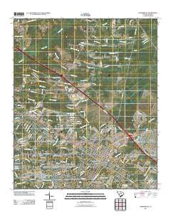
~ Summerville SC topo map, 1:24000 scale, 7.5 X 7.5 Minute, Historical, 2011
Summerville, South Carolina, USGS topographic map dated 2011.
Includes geographic coordinates (latitude and longitude). This topographic map is suitable for hiking, camping, and exploring, or framing it as a wall map.
Printed on-demand using high resolution imagery, on heavy weight and acid free paper, or alternatively on a variety of synthetic materials.
Topos available on paper, Waterproof, Poly, or Tyvek. Usually shipping rolled, unless combined with other folded maps in one order.
- Product Number: USGS-5310862
- Free digital map download (high-resolution, GeoPDF): Summerville, South Carolina (file size: 25 MB)
- Map Size: please refer to the dimensions of the GeoPDF map above
- Weight (paper map): ca. 55 grams
- Map Type: POD USGS Topographic Map
- Map Series: US Topo
- Map Verison: Historical
- Cell ID: 43740
- Datum: North American Datum of 1983
- Map Projection: Transverse Mercator
- Map Cell Name: Summerville
- Grid size: 7.5 X 7.5 Minute
- Date on map: 2011
- Map Scale: 1:24000
- Geographical region: South Carolina, United States
Neighboring Maps:
All neighboring USGS topo maps are available for sale online at a variety of scales.
Spatial coverage:
Topo map Summerville, South Carolina, covers the geographical area associated the following places:
- Lincolnville - Brick Yard Trace - Woodside Manor - Trotters Ridge - Lotts Crossroads - Meadowbrook - Hunters Creek - Millwood - South Pointe - Sawmill Terrace - Shephard Park - Azalea Estates - Clemson Terrace - Robynwyn - Orchard Hill - Warington - Woodbridge - Oak Knoll Estates - Sangaree - Sweetbriar - Waring Hall - Cloverleaf Mobile Home Park - Tea Farm - Challendon - New Hope - Flowertown Estates - Summerville - Huntington Farms - Palmetto Park - Rosehill - Tramway - Jedburg - Pecan Grove - Garbon Subdivision - Pineforest Inn - Washington Town - Knightsville - Brownsville - Cotton Hill - Gadsden Acres - Gadsden Place - Twin Oaks - Pinehill - Corey Wood - Corey Point - Pine Forest Estates
- Map Area ID: AREA33.12533-80.25-80.125
- Northwest corner Lat/Long code: USGSNW33.125-80.25
- Northeast corner Lat/Long code: USGSNE33.125-80.125
- Southwest corner Lat/Long code: USGSSW33-80.25
- Southeast corner Lat/Long code: USGSSE33-80.125
- Northern map edge Latitude: 33.125
- Southern map edge Latitude: 33
- Western map edge Longitude: -80.25
- Eastern map edge Longitude: -80.125


