
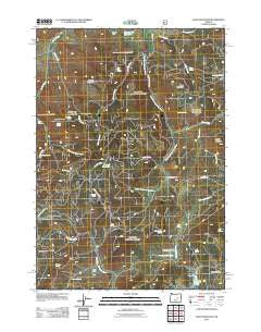
~ Alsup Mountain OR topo map, 1:24000 scale, 7.5 X 7.5 Minute, Historical, 2011
Alsup Mountain, Oregon, USGS topographic map dated 2011.
Includes geographic coordinates (latitude and longitude). This topographic map is suitable for hiking, camping, and exploring, or framing it as a wall map.
Printed on-demand using high resolution imagery, on heavy weight and acid free paper, or alternatively on a variety of synthetic materials.
Topos available on paper, Waterproof, Poly, or Tyvek. Usually shipping rolled, unless combined with other folded maps in one order.
- Product Number: USGS-5310606
- Free digital map download (high-resolution, GeoPDF): Alsup Mountain, Oregon (file size: 24 MB)
- Map Size: please refer to the dimensions of the GeoPDF map above
- Weight (paper map): ca. 55 grams
- Map Type: POD USGS Topographic Map
- Map Series: US Topo
- Map Verison: Historical
- Cell ID: 722
- Datum: North American Datum of 1983
- Map Projection: Transverse Mercator
- Map Cell Name: Alsup Mountain
- Grid size: 7.5 X 7.5 Minute
- Date on map: 2011
- Map Scale: 1:24000
- Geographical region: Oregon, United States
Neighboring Maps:
All neighboring USGS topo maps are available for sale online at a variety of scales.
Spatial coverage:
Topo map Alsup Mountain, Oregon, covers the geographical area associated the following places:
- Brown Ranch (historical) - Carey Ranch (historical) - Donivan Mountain - Buttes Ranch - Clemens Dam - Mud Springs Creek - Dons Spring - Yellowjacket Lake - Crystal Reservoir - Browns Reservoir - Delles Creek Camp - Yellowjacket Field - Rock Creek - Bear Creek - Turner Cabin - Fall Creek - Alsup Creek - Forty-five Spring - Hunter Cabin (historical) - Rickman Ranch - Burnt Spring - Sawtooth Meadows - Mud Springs - Devils Garden Spring - Yellowjacket Recreation Site - Link Spring - Yellowjacket Spring - Rickman Reservoir - Deer Spring - Alsup Mountain - Burnt Mountain - Sawtooth Spring - Burnt Mountain Creek - Sunflower Flat - Siamese Spring - Donivan Creek - K B Spring - Cougar Creek - Delles Creek - Four Bar Spring - Alsup Spring - Sage Hen Flat - Divide Reservoir - Cougar Mountain - Scharff Cabin Creek - Muddy Spring - Spring Valley meadow - Bear Tree Guard Station (historical) - Chris Borg Spring - Bear Tree Spring - Crystal Spring
- Map Area ID: AREA4443.875-119.375-119.25
- Northwest corner Lat/Long code: USGSNW44-119.375
- Northeast corner Lat/Long code: USGSNE44-119.25
- Southwest corner Lat/Long code: USGSSW43.875-119.375
- Southeast corner Lat/Long code: USGSSE43.875-119.25
- Northern map edge Latitude: 44
- Southern map edge Latitude: 43.875
- Western map edge Longitude: -119.375
- Eastern map edge Longitude: -119.25


