
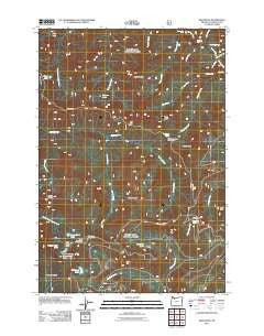
~ High Rock OR topo map, 1:24000 scale, 7.5 X 7.5 Minute, Historical, 2011
High Rock, Oregon, USGS topographic map dated 2011.
Includes geographic coordinates (latitude and longitude). This topographic map is suitable for hiking, camping, and exploring, or framing it as a wall map.
Printed on-demand using high resolution imagery, on heavy weight and acid free paper, or alternatively on a variety of synthetic materials.
Topos available on paper, Waterproof, Poly, or Tyvek. Usually shipping rolled, unless combined with other folded maps in one order.
- Product Number: USGS-5310558
- Free digital map download (high-resolution, GeoPDF): High Rock, Oregon (file size: 28 MB)
- Map Size: please refer to the dimensions of the GeoPDF map above
- Weight (paper map): ca. 55 grams
- Map Type: POD USGS Topographic Map
- Map Series: US Topo
- Map Verison: Historical
- Cell ID: 20378
- Datum: North American Datum of 1983
- Map Projection: Transverse Mercator
- Map Cell Name: High Rock
- Grid size: 7.5 X 7.5 Minute
- Date on map: 2011
- Map Scale: 1:24000
- Geographical region: Oregon, United States
Neighboring Maps:
All neighboring USGS topo maps are available for sale online at a variety of scales.
Spatial coverage:
Topo map High Rock, Oregon, covers the geographical area associated the following places:
- Upper Rock Lake - Hideaway Falls - Shellrock Lake - Vanishing Falls - Swift Creek - High Rock Spring - Hambone Spring - Splintercat Creek - High Rock Quarry - Frazier Turnaround Campground - Plaza Lake - Signal Buttes - Tumbling Creek - Hambone Butte - Wolf Peak - Salmon Butte Trail - Kinzel Creek - Rock Lakes - Sink Quarry - Cache Meadow - High Rock Spring Recreation Site - Black Wolf Meadow Creek - Lower Rock Lake - High Rock Creek - Round Wolf Pit - Pyramid Lake - Final Falls - Goat Creek - Cougar Creek - Rock Lakes Basin - Iron Creek - Middle Rock Lake - Hambone Springs Campground - High Rock - Hambone Trail - Frustration Falls - Salmon Lake - Linney Butte - Salmon Butte - Little Niagara Falls - Frazier Mountain - Frazier Fork Campground - South Fork Ridge Trail - Indian Ridge - Roaring River Trail
- Map Area ID: AREA45.2545.125-122-121.875
- Northwest corner Lat/Long code: USGSNW45.25-122
- Northeast corner Lat/Long code: USGSNE45.25-121.875
- Southwest corner Lat/Long code: USGSSW45.125-122
- Southeast corner Lat/Long code: USGSSE45.125-121.875
- Northern map edge Latitude: 45.25
- Southern map edge Latitude: 45.125
- Western map edge Longitude: -122
- Eastern map edge Longitude: -121.875


