
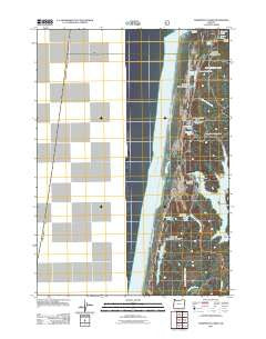
~ Tahkenitch Creek OR topo map, 1:24000 scale, 7.5 X 7.5 Minute, Historical, 2011
Tahkenitch Creek, Oregon, USGS topographic map dated 2011.
Includes geographic coordinates (latitude and longitude). This topographic map is suitable for hiking, camping, and exploring, or framing it as a wall map.
Printed on-demand using high resolution imagery, on heavy weight and acid free paper, or alternatively on a variety of synthetic materials.
Topos available on paper, Waterproof, Poly, or Tyvek. Usually shipping rolled, unless combined with other folded maps in one order.
- Product Number: USGS-5310242
- Free digital map download (high-resolution, GeoPDF): Tahkenitch Creek, Oregon (file size: 12 MB)
- Map Size: please refer to the dimensions of the GeoPDF map above
- Weight (paper map): ca. 55 grams
- Map Type: POD USGS Topographic Map
- Map Series: US Topo
- Map Verison: Historical
- Cell ID: 44190
- Datum: North American Datum of 1983
- Map Projection: Transverse Mercator
- Map Cell Name: Tahkenitch Creek
- Grid size: 7.5 X 7.5 Minute
- Date on map: 2011
- Map Scale: 1:24000
- Geographical region: Oregon, United States
Neighboring Maps:
All neighboring USGS topo maps are available for sale online at a variety of scales.
Spatial coverage:
Topo map Tahkenitch Creek, Oregon, covers the geographical area associated the following places:
- Lost Lake Campground (historical) - Tahkenitch Boat Ramp - Smith River Ranger Station (historical) - Lost Lake - Threemile Lake - Kroll Post Office (historical) - Tahkenitch Lake Dam - Elbow Lake - Kroll - Perkins Lake - Tahkenitch Landing Recreation Site - Elbow Lake Creek - Tahkenitch Trail - Weed Island - Siltcoos Recreation Site - Tahkenitch Creek - Threemile Lake Trail - Spring Point - East Cater Boat Ramp - W D Hull Mill (historical) - Tahkenitch Recreation Site - Bass Arms - Carter Lake Boat Ramp - Deer Arm - Waxmyrtle Trail - Jewitt Island - Crown Zellerback Campground - Georgia Lake - Siltcoos River - Burnt Point - Oregon Dunes Recreation Site - Siltcoos Lookout - East Carter Campground (historical) - Crown Z Lake - Carter Lake Creek - Carter Lake Recreation Site - Butterfly Lake - Tahkenitch Boat Landing - Clay Point - Carter Lake - Erhart Lake - Loon Lake - Overlook Loop Trail - Home Point - Elbow Lake Campground - Shag Arm - Carter Dunes Trail
- Map Area ID: AREA43.87543.75-124.25-124.125
- Northwest corner Lat/Long code: USGSNW43.875-124.25
- Northeast corner Lat/Long code: USGSNE43.875-124.125
- Southwest corner Lat/Long code: USGSSW43.75-124.25
- Southeast corner Lat/Long code: USGSSE43.75-124.125
- Northern map edge Latitude: 43.875
- Southern map edge Latitude: 43.75
- Western map edge Longitude: -124.25
- Eastern map edge Longitude: -124.125


