
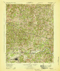
~ Draper NC topo map, 1:62500 scale, 15 X 15 Minute, Historical, 1944
Draper, North Carolina, USGS topographic map dated 1944.
Includes geographic coordinates (latitude and longitude). This topographic map is suitable for hiking, camping, and exploring, or framing it as a wall map.
Printed on-demand using high resolution imagery, on heavy weight and acid free paper, or alternatively on a variety of synthetic materials.
Topos available on paper, Waterproof, Poly, or Tyvek. Usually shipping rolled, unless combined with other folded maps in one order.
- Product Number: USGS-5302820
- Free digital map download (high-resolution, GeoPDF): Draper, North Carolina (file size: 11 MB)
- Map Size: please refer to the dimensions of the GeoPDF map above
- Weight (paper map): ca. 55 grams
- Map Type: POD USGS Topographic Map
- Map Series: HTMC
- Map Verison: Historical
- Cell ID: 320818
- Scan ID: 188058
- Woodland Tint: Yes
- Aerial Photo Year: 1941
- Survey Year: 1924
- Datum: NAD
- Map Projection: Polyconic
- Map published by United States Army Corps of Engineers
- Map published by United States Department of War
- Map Language: English
- Scanner Resolution: 600 dpi
- Map Cell Name: Draper
- Grid size: 15 X 15 Minute
- Date on map: 1944
- Map Scale: 1:62500
- Geographical region: North Carolina, United States
Neighboring Maps:
All neighboring USGS topo maps are available for sale online at a variety of scales.
Spatial coverage:
Topo map Draper, North Carolina, covers the geographical area associated the following places:
- Rickman Acres - Soapstone - Oak Ridge - Cascade - Buford - Whitmell - Powell (historical) - Bachelors Hall - Stockton - Draper (historical) - Northridge - Grand Oaks - Berry Hill - Leaksville Junction - Leatherwood - Callahans Hills - West Fork - Oak Hill - Vandola - Hinesville - Briarfield (historical) - Aiken Summit - Sandy Level - Central Area - Axton - Hickory Grove - Sharon - Fitzgerald - Creekridge - Boxwood - Green Acres - Meadow Summit - Sandy River - Brosville - Vance - Stony Mill - Davis Store - Mayfield - Starlings Crossroads - Swansonville
- Map Area ID: AREA36.7536.5-79.75-79.5
- Northwest corner Lat/Long code: USGSNW36.75-79.75
- Northeast corner Lat/Long code: USGSNE36.75-79.5
- Southwest corner Lat/Long code: USGSSW36.5-79.75
- Southeast corner Lat/Long code: USGSSE36.5-79.5
- Northern map edge Latitude: 36.75
- Southern map edge Latitude: 36.5
- Western map edge Longitude: -79.75
- Eastern map edge Longitude: -79.5


