
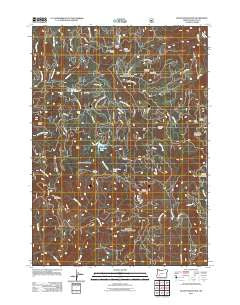
~ Quartz Mountain OR topo map, 1:24000 scale, 7.5 X 7.5 Minute, Historical, 2011
Quartz Mountain, Oregon, USGS topographic map dated 2011.
Includes geographic coordinates (latitude and longitude). This topographic map is suitable for hiking, camping, and exploring, or framing it as a wall map.
Printed on-demand using high resolution imagery, on heavy weight and acid free paper, or alternatively on a variety of synthetic materials.
Topos available on paper, Waterproof, Poly, or Tyvek. Usually shipping rolled, unless combined with other folded maps in one order.
- Product Number: USGS-5295645
- Free digital map download (high-resolution, GeoPDF): Quartz Mountain, Oregon (file size: 28 MB)
- Map Size: please refer to the dimensions of the GeoPDF map above
- Weight (paper map): ca. 55 grams
- Map Type: POD USGS Topographic Map
- Map Series: US Topo
- Map Verison: Historical
- Cell ID: 36758
- Datum: North American Datum of 1983
- Map Projection: Transverse Mercator
- Map Cell Name: Quartz Mountain
- Grid size: 7.5 X 7.5 Minute
- Date on map: 2011
- Map Scale: 1:24000
- Geographical region: Oregon, United States
Neighboring Maps:
All neighboring USGS topo maps are available for sale online at a variety of scales.
Spatial coverage:
Topo map Quartz Mountain, Oregon, covers the geographical area associated the following places:
- Hemlock Meadows Dam - Snowbird Shelter - Horse Prairie - Yellow Jacket Glade - Snowbird Mountain - Dead Cow Lake - Harpham Lake - Hemlock Creek - OK Butte - Hemlock Lake - Cinderella Spring - Yakso Falls - Hemlock Lake Recreation Site - Horn Prairie - Lake in the Woods Recreation Site - South Limpy Prairie - Quartz Mountain Guard Station - Hemlock Falls - Clover Butte - Cavitt Mountain - Limpy Mountain - Hemlock Meadows Recreation Site - Buckhead Mountain Campground - Junction Creek - Twin Lake Creek - Clover Falls - Quartz Mountain - Lake in the Woods Boat Ramp - Pinnacle Creek - Lake in the Woods - Buckhead Trail - Hemlock Lake Boat Ramp - Youtlkut Pillars - Flat Rock - Limpy Prairie - Buck Prairie
- Map Area ID: AREA43.2543.125-122.75-122.625
- Northwest corner Lat/Long code: USGSNW43.25-122.75
- Northeast corner Lat/Long code: USGSNE43.25-122.625
- Southwest corner Lat/Long code: USGSSW43.125-122.75
- Southeast corner Lat/Long code: USGSSE43.125-122.625
- Northern map edge Latitude: 43.25
- Southern map edge Latitude: 43.125
- Western map edge Longitude: -122.75
- Eastern map edge Longitude: -122.625


