
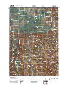
~ Williams Prairie OR topo map, 1:24000 scale, 7.5 X 7.5 Minute, Historical, 2011
Williams Prairie, Oregon, USGS topographic map dated 2011.
Includes geographic coordinates (latitude and longitude). This topographic map is suitable for hiking, camping, and exploring, or framing it as a wall map.
Printed on-demand using high resolution imagery, on heavy weight and acid free paper, or alternatively on a variety of synthetic materials.
Topos available on paper, Waterproof, Poly, or Tyvek. Usually shipping rolled, unless combined with other folded maps in one order.
- Product Number: USGS-5295172
- Free digital map download (high-resolution, GeoPDF): Williams Prairie, Oregon (file size: 21 MB)
- Map Size: please refer to the dimensions of the GeoPDF map above
- Weight (paper map): ca. 55 grams
- Map Type: POD USGS Topographic Map
- Map Series: US Topo
- Map Verison: Historical
- Cell ID: 49155
- Datum: North American Datum of 1983
- Map Projection: Transverse Mercator
- Map Cell Name: Williams Prairie
- Grid size: 7.5 X 7.5 Minute
- Date on map: 2011
- Map Scale: 1:24000
- Geographical region: Oregon, United States
Neighboring Maps:
All neighboring USGS topo maps are available for sale online at a variety of scales.
Spatial coverage:
Topo map Williams Prairie, Oregon, covers the geographical area associated the following places:
- Long Prairie Reservoir - Round Prairie Reservoir - Jungle Creek - Peterson Creek - Hickey Meadow - Crescent Post Office (historical) - Long Prairie - Berkley Spring - Hickey Reservoir - Round Prairie - Brush Creek - Aspen Spring - Williams Spring - Gill Ditch - Lucky Reservoir - Shovel Reservoir - Elliot Creek - Fox Spring - Howard Creek - Indian Creek - Bruner Spring Reservoir - Johnson Creek - Peterson Creek Reservoir - Hickey Creek - Dingus Spring - Hellebore Spring - Williams Prairie - Gill Reservoir - Faith Reservoir - North Fork Reservoir - Cold Springs - Sera Spring - Gill Ranch - Lytle Prairie - Hope Reservoir - Rough Canyon Reservoir - Bruner Spring - Dudley Creek - Fox Reservoir - Snyder Spring - Gray Creek - Indian Trail Spring - South Fox Reservoir - Cold Springs Guard Station - Lookout Creek - Lookout Pasture - Peterson Creek Dam - Little Round Prairie - Allen Creek - North Fox Canyon Creek - Cold Spring Guard Station Landing Field (historical) - Howard Ranch - Big Summit Prairie - Cram Creek - Antler Prairie - Summit Prairie School (historical) - Meadow Post Office (historical) - Ross Creek
- Map Area ID: AREA44.37544.25-120.25-120.125
- Northwest corner Lat/Long code: USGSNW44.375-120.25
- Northeast corner Lat/Long code: USGSNE44.375-120.125
- Southwest corner Lat/Long code: USGSSW44.25-120.25
- Southeast corner Lat/Long code: USGSSE44.25-120.125
- Northern map edge Latitude: 44.375
- Southern map edge Latitude: 44.25
- Western map edge Longitude: -120.25
- Eastern map edge Longitude: -120.125


