
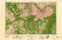
~ Winchester KY topo map, 1:250000 scale, 1 X 2 Degree, Historical, 1960
Winchester, Kentucky, USGS topographic map dated 1960.
Includes geographic coordinates (latitude and longitude). This topographic map is suitable for hiking, camping, and exploring, or framing it as a wall map.
Printed on-demand using high resolution imagery, on heavy weight and acid free paper, or alternatively on a variety of synthetic materials.
Topos available on paper, Waterproof, Poly, or Tyvek. Usually shipping rolled, unless combined with other folded maps in one order.
- Product Number: USGS-5295036
- Free digital map download (high-resolution, GeoPDF): Winchester, Kentucky (file size: 14 MB)
- Map Size: please refer to the dimensions of the GeoPDF map above
- Weight (paper map): ca. 55 grams
- Map Type: POD USGS Topographic Map
- Map Series: HTMC
- Map Verison: Historical
- Cell ID: 69103
- Scan ID: 804112
- Woodland Tint: Yes
- Field Check Year: 1957
- Datum: Unstated
- Map Projection: Transverse Mercator
- Map published by United States Army
- Map Language: English
- Scanner Resolution: 508 dpi
- Map Cell Name: Winchester
- Grid size: 1 X 2 Degree
- Date on map: 1960
- Map Scale: 1:250000
- Geographical region: Kentucky, United States
Neighboring Maps:
All neighboring USGS topo maps are available for sale online at a variety of scales.
Spatial coverage:
Topo map Winchester, Kentucky, covers the geographical area associated the following places:
- Walltown - Faubush - Crab Orchard - Seaville - Moore - Frogtown - Atterson - Russell Springs - Drowing Creek (historical) - Squib - The Forks (historical) - Toddville - Bliss - Brazil - Thompsonville - Edgewood (historical) - Elihu - Wabd - Threelinks - Walnut Hill - Lebanon - Woodstock - Crooksville (historical) - Pellyton - Mount Zenia (historical) - Pink - Portland - Hanly - Logsdon Valley - Windsor - Pelham Branch (historical) - Olivers (historical) - Maplewood (historical) - Fox Creek - Martin Creek (historical) - Gethsemane - Pitts Point - Eli - Salem - Mell - Salleetown - Waynesburg - Haskingsville - Luner - Gentrys Mill - Buggytown - Indian Hills (historical) - Brumfield - Mount Victory - Cedar Creek (historical) - Bluff Boom - Penick - Oregon - Culvertown - Gilbert - Cravens - Mershons - Vine Grove Junction - Ephesus (historical) - Winchester - Crailhope - Hibernia - Three Forks - Vanarsdell - Curry (historical) - Jimtown - Hillcrest - Crackers Neck (historical) - Miracle - Jonesville - Shopville - Sopers (historical) - Chaplin - Summersville - Wrights - Donansburg - White Oak (historical) - Guy (historical) - Vineyard - Whickerville - Jessietown - Grundy - Cedar Grove (historical) - Talley - Gadberry (historical) - South Columbia (historical) - Jackson - Sano - Nevada - Pilot View - Lily - Bohon - Pine Hill - Knob Lick (historical) - Brigadoon - Diamond (historical) - New Market - Hobbs - Poplarville - Hardesty
- Map Area ID: AREA3837-86-84
- Northwest corner Lat/Long code: USGSNW38-86
- Northeast corner Lat/Long code: USGSNE38-84
- Southwest corner Lat/Long code: USGSSW37-86
- Southeast corner Lat/Long code: USGSSE37-84
- Northern map edge Latitude: 38
- Southern map edge Latitude: 37
- Western map edge Longitude: -86
- Eastern map edge Longitude: -84


