
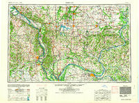
~ Paducah KY topo map, 1:250000 scale, 1 X 2 Degree, Historical, 1964
Paducah, Kentucky, USGS topographic map dated 1964.
Includes geographic coordinates (latitude and longitude). This topographic map is suitable for hiking, camping, and exploring, or framing it as a wall map.
Printed on-demand using high resolution imagery, on heavy weight and acid free paper, or alternatively on a variety of synthetic materials.
Topos available on paper, Waterproof, Poly, or Tyvek. Usually shipping rolled, unless combined with other folded maps in one order.
- Product Number: USGS-5295022
- Free digital map download (high-resolution, GeoPDF): Paducah, Kentucky (file size: 13 MB)
- Map Size: please refer to the dimensions of the GeoPDF map above
- Weight (paper map): ca. 55 grams
- Map Type: POD USGS Topographic Map
- Map Series: HTMC
- Map Verison: Historical
- Cell ID: 68951
- Scan ID: 803857
- Woodland Tint: Yes
- Aerial Photo Year: 1942
- Survey Year: 1948
- Datum: NAD27
- Map Projection: Transverse Mercator
- Map published by United States Army Corps of Engineers
- Map published by United States Army
- Map Language: English
- Scanner Resolution: 508 dpi
- Map Cell Name: Paducah
- Grid size: 1 X 2 Degree
- Date on map: 1964
- Map Scale: 1:250000
- Geographical region: Kentucky, United States
Neighboring Maps:
All neighboring USGS topo maps are available for sale online at a variety of scales.
Spatial coverage:
Topo map Paducah, Kentucky, covers the geographical area associated the following places:
- Leamington - Watkins Ford - Oldtown - Lola - Grand Eddy - Iuka - Carrsville - Spring Grove - Valley Mission - Mullikin Junction - Rock - New Palestine - Hillerman - Aldridge - Cambon - Arnsberg - West End - Chester - Unionville - Grays Point (historical) - Longtown - Vienna - Murphysboro - Cypress - Nash - New Grand Chain - Bandana - Woodlawn - Christopher - Clank - Cimota City - Chiles - Tatumville - Humm Wye - Ingleside - Renshaw - Sleepy Hollow - Sheridan - Eagle Point Bay - Thompsonville - Karnak - Dutchtown - Hartsville - Degognia - Morley - Fergestown - Loimbach Landing - Norris City - New Hope - Farley - Lewis Corner - Gaskins City - Mason - Hallidayboro - Levias - Kimmelton (historical) - Belknap - Hebron (historical) - North Shoreline - Juanitas Mobile Home Park - Cloud Crossing - Dewmaine - Wagon Creek Heaven - Poor Farm (historical) - Scopus - Sisco Chapel (historical) - Carterville - Lone Oak - Evergreen Terrace - Sedgewickville - Eden Bay - Haddox Ferry - Rockview - Junction - Commerce - Cora - Greenacres - Jonesboro - Eichorn - Future City - Matthews - Fredonia - Akin - Bainbridge - Woodland Hills - Hinkleville - Eltham (historical) - Lake Estates - Attila - Campton - Muddy - Reevesville - New Hamburg - Egypt Shores - Saline Landing - Saline Junction - Pleasant Grove - Milburn Chapel (historical) - Southern Hills - Fords Ferry
- Map Area ID: AREA3837-90-88
- Northwest corner Lat/Long code: USGSNW38-90
- Northeast corner Lat/Long code: USGSNE38-88
- Southwest corner Lat/Long code: USGSSW37-90
- Southeast corner Lat/Long code: USGSSE37-88
- Northern map edge Latitude: 38
- Southern map edge Latitude: 37
- Western map edge Longitude: -90
- Eastern map edge Longitude: -88


