
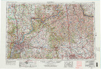
~ Louisville KY topo map, 1:250000 scale, 1 X 2 Degree, Historical, 1956, updated 1976
Louisville, Kentucky, USGS topographic map dated 1956.
Includes geographic coordinates (latitude and longitude). This topographic map is suitable for hiking, camping, and exploring, or framing it as a wall map.
Printed on-demand using high resolution imagery, on heavy weight and acid free paper, or alternatively on a variety of synthetic materials.
Topos available on paper, Waterproof, Poly, or Tyvek. Usually shipping rolled, unless combined with other folded maps in one order.
- Product Number: USGS-5295016
- Free digital map download (high-resolution, GeoPDF): Louisville, Kentucky (file size: 14 MB)
- Map Size: please refer to the dimensions of the GeoPDF map above
- Weight (paper map): ca. 55 grams
- Map Type: POD USGS Topographic Map
- Map Series: HTMC
- Map Verison: Historical
- Cell ID: 68883
- Scan ID: 803728
- Imprint Year: 1976
- Woodland Tint: Yes
- Aerial Photo Year: 1952
- Edit Year: 1969
- Field Check Year: 1956
- Datum: Unstated
- Map Projection: Transverse Mercator
- Map published by: Military, Other
- Map Language: English
- Scanner Resolution: 508 dpi
- Map Cell Name: Louisville
- Grid size: 1 X 2 Degree
- Date on map: 1956
- Map Scale: 1:250000
- Geographical region: Kentucky, United States
Neighboring Maps:
All neighboring USGS topo maps are available for sale online at a variety of scales.
Spatial coverage:
Topo map Louisville, Kentucky, covers the geographical area associated the following places:
- Teresita - Southland - Floyds Knobs - Swanville - Veechdale - Borden - Sylvandell - Searcy Crossroads - Henryville - Ezra (historical) - Forest Hills - Jeffersonville - Elk Chester - Sherman - Dry Ridge - Lower Sweet Owen (historical) - Portland - Prather - Mansfield Estates - Thixton - Lincoln Ridge - Corinth - Saint Dennis - Jeffersontown - White Sulphur - Mount Zion - Honeysuckle (historical) - Fairview - Flagg Spring - Cadentown - Foster - Bridgeville - Oakland (historical) - Gilgal (historical) - Hollyvilla - White Tower - English - Ricedale - Hawthorne - Manville - Happy Hollow - Point Pleasant - Kiserton - Parina (historical) - Easterday - Bel Air - Rivals - Buckner - Cropper - Elmendorf - Reis (historical) - Jericho - Tarascon - Union - New Farmington - Breck - Hopeful (historical) - Cardinal Valley - Anderson City - Escondida - Centerfield - Waddy - Zandale - Munk - Hesler - Memphis - Zion Hill - North Pleasureville - Graefenburg - Poplar Thicket (historical) - Sideview - Fisherville - Maple Valley (historical) - Hurstbourne Acres - Boston - Cedar Brook - Ivor - Fruit Hill (historical) - Lacie - Wiggonsville - Goshen - Robinswood - Ashland Park - Salina - Plantation - West Buechel - Lucas Lane (historical) - Parkway Village - Rexville - Willow - Wilmington (historical) - Gratz - Ten Broeck - Rockwell Village (historical) - Flower Town (historical) - Smithville - Cementville - Christianburg - Long Run - Keefer
- Map Area ID: AREA3938-86-84
- Northwest corner Lat/Long code: USGSNW39-86
- Northeast corner Lat/Long code: USGSNE39-84
- Southwest corner Lat/Long code: USGSSW38-86
- Southeast corner Lat/Long code: USGSSE38-84
- Northern map edge Latitude: 39
- Southern map edge Latitude: 38
- Western map edge Longitude: -86
- Eastern map edge Longitude: -84


