
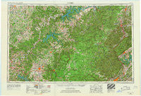
~ Corbin KY topo map, 1:250000 scale, 1 X 2 Degree, Historical, 1956, updated 1966
Corbin, Kentucky, USGS topographic map dated 1956.
Includes geographic coordinates (latitude and longitude). This topographic map is suitable for hiking, camping, and exploring, or framing it as a wall map.
Printed on-demand using high resolution imagery, on heavy weight and acid free paper, or alternatively on a variety of synthetic materials.
Topos available on paper, Waterproof, Poly, or Tyvek. Usually shipping rolled, unless combined with other folded maps in one order.
- Product Number: USGS-5295006
- Free digital map download (high-resolution, GeoPDF): Corbin, Kentucky (file size: 13 MB)
- Map Size: please refer to the dimensions of the GeoPDF map above
- Weight (paper map): ca. 55 grams
- Map Type: POD USGS Topographic Map
- Map Series: HTMC
- Map Verison: Historical
- Cell ID: 68730
- Scan ID: 803429
- Imprint Year: 1966
- Woodland Tint: Yes
- Edit Year: 1965
- Field Check Year: 1956
- Datum: Unstated
- Map Projection: Transverse Mercator
- Map published by United States Geological Survey
- Map Language: English
- Scanner Resolution: 508 dpi
- Map Cell Name: Corbin
- Grid size: 1 X 2 Degree
- Date on map: 1956
- Map Scale: 1:250000
- Geographical region: Kentucky, United States
Neighboring Maps:
All neighboring USGS topo maps are available for sale online at a variety of scales.
Spatial coverage:
Topo map Corbin, Kentucky, covers the geographical area associated the following places:
- Yamacraw - Steubenville - Petite Subdivision - Days Crossroads - Edgefield - Union Hill - Banner Springs - Stalcup - Taylors Crossroads - Jamestown - Bell Bridge - Laurel Hill - North Springs - Waterview - Gobey - Williams Crossroads - Churntop (historical) - Ridgecrest - Firkin (historical) - Windletown - Gentry - Pleasant Ridge - Gilreath Mill - Linger Lake - Hestand - Chance - Charleys Branch - Sumpter - Dean - Spring Hill - Midway - Conley Crossroads (historical) - Walnut Grove - Cub Creek - Seventy Six - Cumberland View Estates - Mount Helen - Monoville - Woodland Estates - Genesis - Star Point - Glenmary - Bethel - Emory (historical) - Hughett - Stanley Junction - Chaska - Laurel - Oz - Gar (historical) - Fairview - Goad - Westfork (historical) - Wartburg - Windle - Baldrock - Burton Estates - Tench - Kidds Crossing - Poplar Grove - Persimmon - Jones Mill - New Haven - Nevelsville - Silerville - Stockton Estates - Garretts Mill - Creekmore - Rockholds - De Lap - Emory Valley - Ponderosa Hills - Cumberland Grove - Cooktown - State Line - Jeffers - Ashlock - Mount Airy - Grandview - Davidson - Number One - Cedar Grove - Caryville - Catoosa Canyon - White Oak - Crocus - Flynns Lick - Wago - Betsey - Beaumont - Petros - Honeybee - Cumberland City - Narvel - East Lake Estates - Highland - Smith Chapel - Alpine Acres - Allons - Verble
- Map Area ID: AREA3736-86-84
- Northwest corner Lat/Long code: USGSNW37-86
- Northeast corner Lat/Long code: USGSNE37-84
- Southwest corner Lat/Long code: USGSSW36-86
- Southeast corner Lat/Long code: USGSSE36-84
- Northern map edge Latitude: 37
- Southern map edge Latitude: 36
- Western map edge Longitude: -86
- Eastern map edge Longitude: -84


