
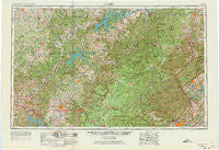
~ Corbin KY topo map, 1:250000 scale, 1 X 2 Degree, Historical, 1956, updated 1973
Corbin, Kentucky, USGS topographic map dated 1956.
Includes geographic coordinates (latitude and longitude). This topographic map is suitable for hiking, camping, and exploring, or framing it as a wall map.
Printed on-demand using high resolution imagery, on heavy weight and acid free paper, or alternatively on a variety of synthetic materials.
Topos available on paper, Waterproof, Poly, or Tyvek. Usually shipping rolled, unless combined with other folded maps in one order.
- Product Number: USGS-5295004
- Free digital map download (high-resolution, GeoPDF): Corbin, Kentucky (file size: 13 MB)
- Map Size: please refer to the dimensions of the GeoPDF map above
- Weight (paper map): ca. 55 grams
- Map Type: POD USGS Topographic Map
- Map Series: HTMC
- Map Verison: Historical
- Cell ID: 68730
- Scan ID: 803428
- Imprint Year: 1973
- Woodland Tint: Yes
- Edit Year: 1965
- Field Check Year: 1956
- Datum: Unstated
- Map Projection: Transverse Mercator
- Map published by United States Army
- Map Language: English
- Scanner Resolution: 508 dpi
- Map Cell Name: Corbin
- Grid size: 1 X 2 Degree
- Date on map: 1956
- Map Scale: 1:250000
- Geographical region: Kentucky, United States
Neighboring Maps:
All neighboring USGS topo maps are available for sale online at a variety of scales.
Spatial coverage:
Topo map Corbin, Kentucky, covers the geographical area associated the following places:
- Alpine - Dorthae - Oakley - Baxter - Mayland - Ponderosa Hills - Remy - Russell Hill - Dixie - College Heights - Samaria - Ashcroft Subdivision - Little Crab - Belmont - Foster Crossroads - Fairview - Jellico - Little White Oak - Avoton (historical) - Mount Airy - Sugar Creek - Mayview Heights - Denney - Glenmary - Frog Pond - Forest Hill (historical) - Hillwood Estates - Heathwood - Flat Creek - Pleasant View - Hidalgo - Tupper Town - Allons - Temple Hill - Littrell - McClures Bend - Ivy Gap (historical) - Lee (historical) - Creston - Brotherton - Twinton - Laurel Hill - Cabell - Graveltown - Grove - Macedonia - New Haven - Blue John - Livingston - Balltown - Spring Hill - Bangham Village - Briceville - Rockbridge - Cove Creek - Briargate - Packard - Baldrock - Sebowisha - Maupin (historical) - Green Brier - Cedar Flats - Ridgewood - LaFollette - Shepherd Hills - Moore Hill - Siler - Difficult - Williams Crossroads - Qualls (historical) - Fork Mountain - Mount Hermon - Cliff Springs - Denton Crossroads - Cloyds Landing - Town and Country Estates - Davis Chapel - McCoinsville - Duff - Burnside - Stanley Junction - Springdale - Ono - Bronston - Candyland Estates - Bell Bridge - Jimtown - Paoli (historical) - Burkesville - Comargo - Barthell - Oak Ridge - Green Valley - Emory Heights - Catoosa - Claxton - Helena - Clementsville - Hopkins (historical) - Darwin Park
- Map Area ID: AREA3736-86-84
- Northwest corner Lat/Long code: USGSNW37-86
- Northeast corner Lat/Long code: USGSNE37-84
- Southwest corner Lat/Long code: USGSSW36-86
- Southeast corner Lat/Long code: USGSSE36-84
- Northern map edge Latitude: 37
- Southern map edge Latitude: 36
- Western map edge Longitude: -86
- Eastern map edge Longitude: -84


