
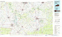
~ Harrodsburg KY topo map, 1:100000 scale, 30 X 60 Minute, Historical, 1986, updated 1986
Harrodsburg, Kentucky, USGS topographic map dated 1986.
Includes geographic coordinates (latitude and longitude). This topographic map is suitable for hiking, camping, and exploring, or framing it as a wall map.
Printed on-demand using high resolution imagery, on heavy weight and acid free paper, or alternatively on a variety of synthetic materials.
Topos available on paper, Waterproof, Poly, or Tyvek. Usually shipping rolled, unless combined with other folded maps in one order.
- Product Number: USGS-5294824
- Free digital map download (high-resolution, GeoPDF): Harrodsburg, Kentucky (file size: 14 MB)
- Map Size: please refer to the dimensions of the GeoPDF map above
- Weight (paper map): ca. 55 grams
- Map Type: POD USGS Topographic Map
- Map Series: HTMC
- Map Verison: Historical
- Cell ID: 67641
- Scan ID: 710070
- Imprint Year: 1986
- Woodland Tint: Yes
- Aerial Photo Year: 1984
- Edit Year: 1986
- Datum: NAD27
- Map Projection: Universal Transverse Mercator
- Planimetric: Yes
- Map published by United States Geological Survey
- Map Language: English
- Scanner Resolution: 508 dpi
- Map Cell Name: Harrodsburg
- Grid size: 30 X 60 Minute
- Date on map: 1986
- Map Scale: 1:100000
- Geographical region: Kentucky, United States
Neighboring Maps:
All neighboring USGS topo maps are available for sale online at a variety of scales.
Spatial coverage:
Topo map Harrodsburg, Kentucky, covers the geographical area associated the following places:
- Baker (historical) - Lancaster - Jackson Ferry (historical) - Sleettown (historical) - Rightangle - Wisemantown - Curry (historical) - Braxton - Noland - Nevada - Pink - Terrill - Newby - Maple Lawn (historical) - Edgewood (historical) - Needmore - Keene - Slate Lick - Epperson (historical) - Dry Fork (historical) - Crooked Creek (historical) - Point Leavell - Shelby City - Morgan Manor Addition - Drowing Creek (historical) - South Elkhorn - Davistown - Kirkwood - Morrill - Million - Hall - Alexander School Neighborhood (historical) - Brumfield - Sweet Home (historical) - Vineyard - Southeastern Hills - Elkin - Nicholasville - Bobtown - College Hill - Palmer - Hargett - Hickory Grove (historical) - Round Hill - Franklin (historical) - Union Mills - Cottonburg - Union City - Brannon - Arlington - Spears - Locust Branch - Fox Creek - Flanagan - Bellevue (historical) - Lexington Park (historical) - Crow Valley - Bryantsville - Indian Hills (historical) - Knob Lick (historical) - Bruners Chapel (historical) - Faulconer - Dixon Town - Kingston - Monticello - New Union (historical) - McCormack (historical) - Bourne - Wilsonville - Blueberry Hill - Milledgeville - Talmage - Battle (historical) - Big Hill (historical) - Ballard - Grapevine (historical) - Colby Hills - Forkland - Iron Mound - Tebbs - Clarksville (historical) - Mount Lebanon - Goshen - Pollard - Judson - Nevin - Fishers Station (historical) - Nealton - Witt Springs - Dreyfus - Mayo - Marcellus - Crooksville (historical) - Watts Store (historical) - Shawnee Run (historical) - Lyndale - Harris Creek (historical) - Lowell - Pinckard - Logana
- Map Area ID: AREA3837.5-85-84
- Northwest corner Lat/Long code: USGSNW38-85
- Northeast corner Lat/Long code: USGSNE38-84
- Southwest corner Lat/Long code: USGSSW37.5-85
- Southeast corner Lat/Long code: USGSSE37.5-84
- Northern map edge Latitude: 38
- Southern map edge Latitude: 37.5
- Western map edge Longitude: -85
- Eastern map edge Longitude: -84


