
~ Corbin KY topo map, 1:100000 scale, 30 X 60 Minute, Historical, 1981, updated 1984
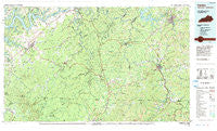
Corbin, Kentucky, USGS topographic map dated 1981.
Includes geographic coordinates (latitude and longitude). This topographic map is suitable for hiking, camping, and exploring, or framing it as a wall map.
Printed on-demand using high resolution imagery, on heavy weight and acid free paper, or alternatively on a variety of synthetic materials.
Topos available on paper, Waterproof, Poly, or Tyvek. Usually shipping rolled, unless combined with other folded maps in one order.
- Product Number: USGS-5294814
- Free digital map download (high-resolution, GeoPDF): Corbin, Kentucky (file size: 21 MB)
- Map Size: please refer to the dimensions of the GeoPDF map above
- Weight (paper map): ca. 55 grams
- Map Type: POD USGS Topographic Map
- Map Series: HTMC
- Map Verison: Historical
- Cell ID: 67337
- Scan ID: 710065
- Imprint Year: 1984
- Woodland Tint: Yes
- Aerial Photo Year: 1980
- Edit Year: 1981
- Datum: NAD27
- Map Projection: Universal Transverse Mercator
- Map published by United States Geological Survey
- Map Language: English
- Scanner Resolution: 508 dpi
- Map Cell Name: Corbin
- Grid size: 30 X 60 Minute
- Date on map: 1981
- Map Scale: 1:100000
- Geographical region: Kentucky, United States
Neighboring Maps:
All neighboring USGS topo maps are available for sale online at a variety of scales.
Spatial coverage:
Topo map Corbin, Kentucky, covers the geographical area associated the following places:
- Barrier - Hidalgo - Oz - Redbird - Hardwick - Travisville - Quinton - Packard - Highcliff - Corbin - Baldrock - Walden - Powersburg - Eadsville - Windy - Nevelsville - Fairview - Strunk - Gatliff - Alpine - Honeybee - Low Gap - Perkins - West Oneida - Tackett Creek - Sawyer - Hopewell - Hollyhill - Ramsey Island - Camp Grounds - Indian Hills - Gray - Parmleysville - Sunnybrook - Shearer Valley - Cooper - Hill Top - Nevisdale - Creekmore - Slavans - Chaska - Sharp Place - Pleasant View - Touristville - Hickory Grove - Marshes Siding - Winfield - Red Ash - Susie - Julip - Bon - Griffin - Sumpter - Ayers - Jellico - Louden - Faber - Isham - Vox - Rankin - Flat Rock - Forbus - Pueblo - Stinking Creek - Lot - White Oak Junction - Tateville - Omega - Bauer - Coopersville - Shelly Knob Camp (historical) - Louden Coal Camp (historical) - Swifton - Gilreath - Revelo - Woodbine - Balltown - State Line - Sloans Valley - Monticello - Emlyn - Parnell - Silerville - Watts Creek Jellico Coal Company (historical) - Sandclift - Dorthae - Verne - Bronston - Hargis - Number One - Little White Oak - Newcomb - Kidder - Moore Hill - White Oak - Savoy - Wooldridge - Fidelity - Pine Knot - Elva (historical)
- Map Area ID: AREA3736.5-85-84
- Northwest corner Lat/Long code: USGSNW37-85
- Northeast corner Lat/Long code: USGSNE37-84
- Southwest corner Lat/Long code: USGSSW36.5-85
- Southeast corner Lat/Long code: USGSSE36.5-84
- Northern map edge Latitude: 37
- Southern map edge Latitude: 36.5
- Western map edge Longitude: -85
- Eastern map edge Longitude: -84


