
~ Campbellsville KY topo map, 1:100000 scale, 30 X 60 Minute, Historical, 1986, updated 1986
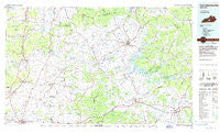
Campbellsville, Kentucky, USGS topographic map dated 1986.
Includes geographic coordinates (latitude and longitude). This topographic map is suitable for hiking, camping, and exploring, or framing it as a wall map.
Printed on-demand using high resolution imagery, on heavy weight and acid free paper, or alternatively on a variety of synthetic materials.
Topos available on paper, Waterproof, Poly, or Tyvek. Usually shipping rolled, unless combined with other folded maps in one order.
- Product Number: USGS-5294812
- Free digital map download (high-resolution, GeoPDF): Campbellsville, Kentucky (file size: 14 MB)
- Map Size: please refer to the dimensions of the GeoPDF map above
- Weight (paper map): ca. 55 grams
- Map Type: POD USGS Topographic Map
- Map Series: HTMC
- Map Verison: Historical
- Cell ID: 67220
- Scan ID: 710064
- Imprint Year: 1986
- Woodland Tint: Yes
- Aerial Photo Year: 1985
- Edit Year: 1986
- Datum: NAD27
- Map Projection: Universal Transverse Mercator
- Planimetric: Yes
- Map published by United States Geological Survey
- Map Language: English
- Scanner Resolution: 508 dpi
- Map Cell Name: Campbellsville
- Grid size: 30 X 60 Minute
- Date on map: 1986
- Map Scale: 1:100000
- Geographical region: Kentucky, United States
Neighboring Maps:
All neighboring USGS topo maps are available for sale online at a variety of scales.
Spatial coverage:
Topo map Campbellsville, Kentucky, covers the geographical area associated the following places:
- Gabe - Bramlett - Tabor (historical) - Eve - Creston - Horse Cave - Nell - Shady Grove - Yuma - Bliss - Casey Creek - Clarks Corner - South Columbia (historical) - Pierce - Pellyton - Mount Sherman - Pascal - Hatcher - Woodsonville - Bloyds Crossing - Greensburg - Grab - Forestville - LeGrande - Hardyville - Thurlow - Pike View - Uno - Arbuckle (historical) - Glens Fork - Bradfordsville - Black Gnat - Clear Creek (historical) - Purdy - Allendale - Neatsville - Hinesdale - In The Bark of Wonderland (historical) - Columbia - Riders Mill - Pitman - Wabash - Cyclone (historical) - Rowletts - Melrose - Sweeneyville - Kessinger - White Rose - Node - Holmes - South Campbellsville - Badger - Finley - Pine Grove (historical) - Park - Defries - Absher - Bengal - Flatwood - Gentrys Mill - Portland - Webbs - Aurbuckle (historical) - Donansburg - Coakley - Middletown - Fonthill - Vento - Humble - Munfordville - Old Linwood (historical) - Jacktown - Wigwam (historical) - Willowtown - Riffe Creek (historical) - Wisdom - Millerfield (historical) - Summersville - Hiseville - Monroe - Sano - Garlin - Keith (historical) - Spurlington - Phillipsburg - Speck - Hobson - Perryville - Fairplay - Rex - Royville - Logsdon Valley - Hudgins - Lecta - Elk Horn - Prices Creek (historical) - Bear Wallow - Gilboa (historical) - Lobb - Echo
- Map Area ID: AREA37.537-86-85
- Northwest corner Lat/Long code: USGSNW37.5-86
- Northeast corner Lat/Long code: USGSNE37.5-85
- Southwest corner Lat/Long code: USGSSW37-86
- Southeast corner Lat/Long code: USGSSE37-85
- Northern map edge Latitude: 37.5
- Southern map edge Latitude: 37
- Western map edge Longitude: -86
- Eastern map edge Longitude: -85


