
~ Bowling Green KY topo map, 1:100000 scale, 30 X 60 Minute, Historical, 1985, updated 1998
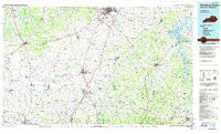
Bowling Green, Kentucky, USGS topographic map dated 1985.
Includes geographic coordinates (latitude and longitude). This topographic map is suitable for hiking, camping, and exploring, or framing it as a wall map.
Printed on-demand using high resolution imagery, on heavy weight and acid free paper, or alternatively on a variety of synthetic materials.
Topos available on paper, Waterproof, Poly, or Tyvek. Usually shipping rolled, unless combined with other folded maps in one order.
- Product Number: USGS-5294806
- Free digital map download (high-resolution, GeoPDF): Bowling Green, Kentucky (file size: 14 MB)
- Map Size: please refer to the dimensions of the GeoPDF map above
- Weight (paper map): ca. 55 grams
- Map Type: POD USGS Topographic Map
- Map Series: HTMC
- Map Verison: Historical
- Cell ID: 67174
- Scan ID: 710062
- Imprint Year: 1998
- Woodland Tint: Yes
- Aerial Photo Year: 1980
- Edit Year: 1985
- Datum: NAD27
- Map Projection: Universal Transverse Mercator
- Planimetric: Yes
- Map published by United States Geological Survey
- Map Language: English
- Scanner Resolution: 508 dpi
- Map Cell Name: Bowling Green
- Grid size: 30 X 60 Minute
- Date on map: 1985
- Map Scale: 1:100000
- Geographical region: Kentucky, United States
Neighboring Maps:
All neighboring USGS topo maps are available for sale online at a variety of scales.
Spatial coverage:
Topo map Bowling Green, Kentucky, covers the geographical area associated the following places:
- Yesse - Costelow - Trammel - Smyrna (historical) - Reubensville - Eulia - Blue Level - Calistia - Bransford - Indian Hills - Highland - Antioch (historical) - Old Zion (historical) - Auburn (historical) - Berry Store - Three Springs - Orlinda - Providence - Highland - Pope - Mount Aerial - Three Forks - Collett (historical) - Red Cross - Portland - Post Oak (historical) - Pleasant Valley - Eastland Park - Raley Ford - Gotts - Kedron (historical) - Forest Springs - Walnut Grove (historical) - Red Hill - Maynard - Scottsville - Stevenson (historical) - Oak Grove (historical) - McElroy Ford - Mount Union (historical) - Sengtown - Cave Springs - Springhill - Cross Plains - Gap of the Ridge - Allen Springs - Halfway - Hydro - Highland Rim Terrace - Hilltop - Lake Spring (historical) - Oakland (historical) - Halifax - Danby - Rogers - Cedar Grove (historical) - Edwards - Chestnut Hill - Nubia - Black Jack - Kinneys - Geddes - Plano - Oak Grove (historical) - Mount Victor - Long Creek - Wixtown - Holland - South Union - Paradise (historical) - Middleton - Dripping Spring (historical) - Locust Grove (historical) - Adairville - Meador - Pondsville - Sylvan (historical) - Kepler - Rockfield - Oakville - Peden Mill - Lamont - Clare - Martinsville - Rocky Hill - Withamtown - Rodemer - Hubertville - Lost River - Neosheo - Hayesville - Bibbtown (historical) - Middle Bridge - Alonzo - New Roe - Maple Grove - Salmons - Sugar Grove - Lafayette - Hardcastle
- Map Area ID: AREA3736.5-87-86
- Northwest corner Lat/Long code: USGSNW37-87
- Northeast corner Lat/Long code: USGSNE37-86
- Southwest corner Lat/Long code: USGSSW36.5-87
- Southeast corner Lat/Long code: USGSSE36.5-86
- Northern map edge Latitude: 37
- Southern map edge Latitude: 36.5
- Western map edge Longitude: -87
- Eastern map edge Longitude: -86


