
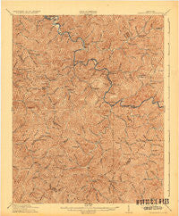
~ Cornettsville KY topo map, 1:62500 scale, 15 X 15 Minute, Historical, 1916, updated 1932
Cornettsville, Kentucky, USGS topographic map dated 1916.
Includes geographic coordinates (latitude and longitude). This topographic map is suitable for hiking, camping, and exploring, or framing it as a wall map.
Printed on-demand using high resolution imagery, on heavy weight and acid free paper, or alternatively on a variety of synthetic materials.
Topos available on paper, Waterproof, Poly, or Tyvek. Usually shipping rolled, unless combined with other folded maps in one order.
- Product Number: USGS-5294336
- Free digital map download (high-resolution, GeoPDF): Cornettsville, Kentucky (file size: 8 MB)
- Map Size: please refer to the dimensions of the GeoPDF map above
- Weight (paper map): ca. 55 grams
- Map Type: POD USGS Topographic Map
- Map Series: HTMC
- Map Verison: Historical
- Cell ID: 52949
- Scan ID: 804149
- Imprint Year: 1932
- Survey Year: 1913
- Datum: NAD
- Map Projection: Polyconic
- Map published by United States Geological Survey
- Map Language: English
- Scanner Resolution: 508 dpi
- Map Cell Name: Cornettsville
- Grid size: 15 X 15 Minute
- Date on map: 1916
- Map Scale: 1:62500
- Geographical region: Kentucky, United States
Neighboring Maps:
All neighboring USGS topo maps are available for sale online at a variety of scales.
Spatial coverage:
Topo map Cornettsville, Kentucky, covers the geographical area associated the following places:
- Daley - Jeff - Wentz - Cornettsville - Fusonia - Hallie - Middle Fork (historical) - Happy - Big Branch (historical) - Scuddy - Delphia - Lothair - Dow - Woodland Park - Slemp - Banks - Beehive (historical) - Daisy - Carr Fork (historical) - Viper - Kodak - Big Fork - Turkey Creek (historical) - Curly Fork (historical) - Ulvah - Hazard - Leatherwood - Wiscoal - Eversole (historical) - Tilford - Beech Fork (historical) - Big Rock - Allock - Defiance - Glomawr - Fourseam - Sassafras - Acup (historical) - Fuson (historical) - Anco - Frew - Diablock - Browns Fork - Vicco - Farler - Christopher - Yeaddiss
- Map Area ID: AREA37.2537-83.25-83
- Northwest corner Lat/Long code: USGSNW37.25-83.25
- Northeast corner Lat/Long code: USGSNE37.25-83
- Southwest corner Lat/Long code: USGSSW37-83.25
- Southeast corner Lat/Long code: USGSSE37-83
- Northern map edge Latitude: 37.25
- Southern map edge Latitude: 37
- Western map edge Longitude: -83.25
- Eastern map edge Longitude: -83


