
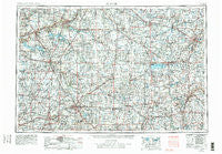
~ Muncie IN topo map, 1:250000 scale, 1 X 2 Degree, Historical, 1953, updated 1979
Muncie, Indiana, USGS topographic map dated 1953.
Includes geographic coordinates (latitude and longitude). This topographic map is suitable for hiking, camping, and exploring, or framing it as a wall map.
Printed on-demand using high resolution imagery, on heavy weight and acid free paper, or alternatively on a variety of synthetic materials.
Topos available on paper, Waterproof, Poly, or Tyvek. Usually shipping rolled, unless combined with other folded maps in one order.
- Product Number: USGS-5289258
- Free digital map download (high-resolution, GeoPDF): Muncie, Indiana (file size: 16 MB)
- Map Size: please refer to the dimensions of the GeoPDF map above
- Weight (paper map): ca. 55 grams
- Map Type: POD USGS Topographic Map
- Map Series: HTMC
- Map Verison: Historical
- Cell ID: 68926
- Scan ID: 160085
- Imprint Year: 1979
- Woodland Tint: Yes
- Visual Version Number: 2
- Aerial Photo Year: 1977
- Edit Year: 1978
- Field Check Year: 1953
- Datum: Unstated
- Map Projection: Transverse Mercator
- Map published by United States Geological Survey
- Map Language: English
- Scanner Resolution: 600 dpi
- Map Cell Name: Muncie
- Grid size: 1 X 2 Degree
- Date on map: 1953
- Map Scale: 1:250000
- Geographical region: Indiana, United States
Neighboring Maps:
All neighboring USGS topo maps are available for sale online at a variety of scales.
Spatial coverage:
Topo map Muncie, Indiana, covers the geographical area associated the following places:
- New Corydon - Buena Vista - Sherwood Manor - Conwood Estates - Overlook Trailer Park - Swayzee - West Liberty - Park Trailer Park - Grandview - Brookhaven - Northview Mobile Village - Elroy - Farrington - Stony Ridge - Western Village - Country Estates - Meyers Mobile Home Park - Twin Lakes (historical) - Lancaster - Woodlawn Trailer Park Number 2 - Liber - Lincolnville - Westbrook - New Pittsburg - Stonebridge Meadows - Buckhorn Corner - Hardin - Scott - Spall's Mobile Home Village - Sidney - Mendon - Ossian - Goblesville - Pikeville - Maplecrest - Roseburg - Trenton - Nottingham - Villa Nova - Anna - Meyers (historical) - Sweetser - Hoagland - Lock Two - Middle Point - Bryant - Westlake Village - Osgood - Richey - Royerton - Bippus - Florida - Unionport - Roann - Elgin - Stonebridge - Village Courts II - Celina - Valentine (historical) - Breezewood - Chesterfield - Ottoville - Pusheta Town (historical) - Jerome - Jonestown - Berne - Hill Grove - Arcana - Fairfax - Pinch - Wildcat Woods Estates - Gas City - Briarwood Court - Medford - Bowers Mobile Home Park - Springport - Arbar Acres - Oakmont Creek - Edgewood - Midway - Allentown - Lake Wood - Majenica - Ballou - Hechts Landing - College Corner - Stanfield Place - Haysville Corner - Travisville - South Shore Acres - Buckland - Buena Vista (historical) - Jeff - Gordons Trailer Court - Perkinsville - Saint Johns - Minster - Long - Roanoke Station - Antiville
- Map Area ID: AREA4140-86-84
- Northwest corner Lat/Long code: USGSNW41-86
- Northeast corner Lat/Long code: USGSNE41-84
- Southwest corner Lat/Long code: USGSSW40-86
- Southeast corner Lat/Long code: USGSSE40-84
- Northern map edge Latitude: 41
- Southern map edge Latitude: 40
- Western map edge Longitude: -86
- Eastern map edge Longitude: -84


