
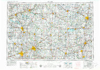
~ Muncie IN topo map, 1:250000 scale, 1 X 2 Degree, Historical, 1953, updated 1979
Muncie, Indiana, USGS topographic map dated 1953.
Includes geographic coordinates (latitude and longitude). This topographic map is suitable for hiking, camping, and exploring, or framing it as a wall map.
Printed on-demand using high resolution imagery, on heavy weight and acid free paper, or alternatively on a variety of synthetic materials.
Topos available on paper, Waterproof, Poly, or Tyvek. Usually shipping rolled, unless combined with other folded maps in one order.
- Product Number: USGS-5289256
- Free digital map download (high-resolution, GeoPDF): Muncie, Indiana (file size: 16 MB)
- Map Size: please refer to the dimensions of the GeoPDF map above
- Weight (paper map): ca. 55 grams
- Map Type: POD USGS Topographic Map
- Map Series: HTMC
- Map Verison: Historical
- Cell ID: 68926
- Scan ID: 160084
- Imprint Year: 1979
- Woodland Tint: Yes
- Visual Version Number: 1
- Aerial Photo Year: 1977
- Edit Year: 1978
- Field Check Year: 1953
- Datum: Unstated
- Map Projection: Transverse Mercator
- Map published by United States Geological Survey
- Map Language: English
- Scanner Resolution: 600 dpi
- Map Cell Name: Muncie
- Grid size: 1 X 2 Degree
- Date on map: 1953
- Map Scale: 1:250000
- Geographical region: Indiana, United States
Neighboring Maps:
All neighboring USGS topo maps are available for sale online at a variety of scales.
Spatial coverage:
Topo map Muncie, Indiana, covers the geographical area associated the following places:
- Spencerville - Douglas - Gimco City - Meadows Glen - Maxville - Westhaven - Durbin - New Lancaster - Southbrook - Kings Chapel - Portland - Ijamsville - Bracken - Rousculp - Pleasant Plain - Jones City - Bass Landing - Saint Marys - New Bremen - Laurel Creek - Maplecrest - Union City - Buckeye - Nottinghill - Swayzee - Randolph - Ceylon - West Liberty - Padua - Monticello - Houston - Sharpeye - Stockport - Sherwood Manor - South Haven - Westlake Village - Fort Jefferson - Emporia - Bippus - Mount Pleasant (historical) - Radley - Anderson - Hawk Cove - Villa Nova - Fourmans Corners - Roll - Glyn Ellen - Shasta (historical) - Modoc - Farrville - Country Club Heights - Ulm's Mobile Home Court I - Cranberry Prairie - Hillcrest - Nashville - Sims - Ellemans (historical) - Abanaka - Bolivar - Landis - Gutman - Shedville - Berne - Alcony - Eastwood Estates - Striptown (historical) - Saint Patrick - Scott Corner - Hartford City - Yoder - Jaysville - Upland - Huntsville - Middlebury - Roseburg - Irondale - Greene - Sharps Crossing - Valentine (historical) - Tama - Muntanna - Sunnymede - Fort Recovery - Elm Tree Crossroads - Plevna - Five Points - Erastus - Crete - Colony Mobile Home Park - Park Trailer Park - Dixon - Peoria - Gates Corner - Shadeland - Saint Johns - Rockford - Turtle Neck Point - Monroeville - Bloomer - Arba
- Map Area ID: AREA4140-86-84
- Northwest corner Lat/Long code: USGSNW41-86
- Northeast corner Lat/Long code: USGSNE41-84
- Southwest corner Lat/Long code: USGSSW40-86
- Southeast corner Lat/Long code: USGSSE40-84
- Northern map edge Latitude: 41
- Southern map edge Latitude: 40
- Western map edge Longitude: -86
- Eastern map edge Longitude: -84


