
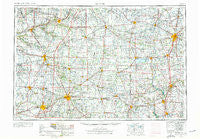
~ Muncie IN topo map, 1:250000 scale, 1 X 2 Degree, Historical, 1953, updated 1976
Muncie, Indiana, USGS topographic map dated 1953.
Includes geographic coordinates (latitude and longitude). This topographic map is suitable for hiking, camping, and exploring, or framing it as a wall map.
Printed on-demand using high resolution imagery, on heavy weight and acid free paper, or alternatively on a variety of synthetic materials.
Topos available on paper, Waterproof, Poly, or Tyvek. Usually shipping rolled, unless combined with other folded maps in one order.
- Product Number: USGS-5289254
- Free digital map download (high-resolution, GeoPDF): Muncie, Indiana (file size: 16 MB)
- Map Size: please refer to the dimensions of the GeoPDF map above
- Weight (paper map): ca. 55 grams
- Map Type: POD USGS Topographic Map
- Map Series: HTMC
- Map Verison: Historical
- Cell ID: 68926
- Scan ID: 160083
- Imprint Year: 1976
- Woodland Tint: Yes
- Edit Year: 1965
- Field Check Year: 1953
- Datum: Unstated
- Map Projection: Transverse Mercator
- Map published by United States Geological Survey
- Map Language: English
- Scanner Resolution: 600 dpi
- Map Cell Name: Muncie
- Grid size: 1 X 2 Degree
- Date on map: 1953
- Map Scale: 1:250000
- Geographical region: Indiana, United States
Neighboring Maps:
All neighboring USGS topo maps are available for sale online at a variety of scales.
Spatial coverage:
Topo map Muncie, Indiana, covers the geographical area associated the following places:
- Hawks Nest - Ossian - Maxville - Windridge Place - Converse - Trenton - Edgehill - Rineharts (historical) - Kalida - Bucks Corner - Wood Haven Mobile Home Park - Saint Marys - West Liberty - Earls Island - Mount Heron - Coldwater Beach - Harmeson Heights - Indian Village Mobile Home Park - Pikeville - Matamoras - Bloomfield - Winchester - Cobblestone Pointe - Fort Shawnee - Banquo - Luray - Hartford City - Horatio - Spencerville - Jonesboro - Woodington - Buena Vista - College Corner - Fletcher - Ceylon - Elwood - Tocsin - Park Trailer Park - Moonville - Do Well Mobile Village - Ballou - Northwood Mobile Home Court - Hechts Landing - Allentown - Christopher Northbrook Mobile Home Park - Stockport - Randolph - Eldean - Reed Station - Andersonville - Ulm's Mobile Home Court I - Decatur - Fowlerton - Hawk Cove - Durbin - Richey - Gimco City - Westside Mobile Home Community - River Forest - Jerome - Roanoke Station - Edgewood - Osgood - Woodland Park - Weaver - Middletown - Meyers Mobile Home Park - Coldwater - Lightsville - Green Acres - Daleville - Geyer - College Corner - Baker - Seitz - Nottinghill - Union City - Janney - Poe - Mendon - Ohio City - America - Port Jefferson - Steinman (historical) - Cranberry Prairie - Cammack - Fairfax - Douglas - Stonebridge Meadows - Delvin (historical) - Omega - Wolfcale - Brookside - Filburns Island - Hinton - Berne - Sharps Crossing - Stanfield Place - Scott Corner - Clayton
- Map Area ID: AREA4140-86-84
- Northwest corner Lat/Long code: USGSNW41-86
- Northeast corner Lat/Long code: USGSNE41-84
- Southwest corner Lat/Long code: USGSSW40-86
- Southeast corner Lat/Long code: USGSSE40-84
- Northern map edge Latitude: 41
- Southern map edge Latitude: 40
- Western map edge Longitude: -86
- Eastern map edge Longitude: -84


