
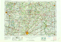
~ Fort Wayne IN topo map, 1:250000 scale, 1 X 2 Degree, Historical, 1953, updated 1963
Fort Wayne, Indiana, USGS topographic map dated 1953.
Includes geographic coordinates (latitude and longitude). This topographic map is suitable for hiking, camping, and exploring, or framing it as a wall map.
Printed on-demand using high resolution imagery, on heavy weight and acid free paper, or alternatively on a variety of synthetic materials.
Topos available on paper, Waterproof, Poly, or Tyvek. Usually shipping rolled, unless combined with other folded maps in one order.
- Product Number: USGS-5289234
- Free digital map download (high-resolution, GeoPDF): Fort Wayne, Indiana (file size: 16 MB)
- Map Size: please refer to the dimensions of the GeoPDF map above
- Weight (paper map): ca. 55 grams
- Map Type: POD USGS Topographic Map
- Map Series: HTMC
- Map Verison: Historical
- Cell ID: 68788
- Scan ID: 156495
- Imprint Year: 1963
- Woodland Tint: Yes
- Aerial Photo Year: 1952
- Edit Year: 1962
- Field Check Year: 1953
- Datum: Unstated
- Map Projection: Transverse Mercator
- Map published by United States Geological Survey
- Map Language: English
- Scanner Resolution: 600 dpi
- Map Cell Name: Fort Wayne
- Grid size: 1 X 2 Degree
- Date on map: 1953
- Map Scale: 1:250000
- Geographical region: Indiana, United States
Neighboring Maps:
All neighboring USGS topo maps are available for sale online at a variety of scales.
Spatial coverage:
Topo map Fort Wayne, Indiana, covers the geographical area associated the following places:
- New Harrison (historical) - Ellison - Four Presidents Corners - Russels Point - Eagle Point - North Creek - Upper Tauwa (historical) - Manor Woods - Addison - Damascus (historical) - Maplecrest - Otsego Center - Broughton - Fairfield Center - Tree Meadows Mobile Home Park - Bankers - Levert - Saint Andrews (historical) - Elmira - Emma - Maples - Three Rivers - Coldwater - Laud - Manleys Subdivision - The Bend - Spring Beach - Greyhound - Tall Timbers - Saint Johns - Academie - Cosperville - Huntertown - Emmett - Between-The-Lakes Park - Meadow Lane Village Mobile Home Park - South Park - Domerville (historical) - Topeka - Townley - Haller (historical) - Highbanks - Napoleon - Jewell - Enchanted Hills - Renollet (historical) - Brighton - Hallock - Avilla - Sunnymeadow - Reading - New Bavaria - Woodland Hills - Shaffers Acres - Timber Creek - Ashley - Lueneburg - Collins - Circle Park - South Milford - Lagrange - Valleybrook Estates - Wooster - Altona - De Camp Gardens - Logan - Zone - Tri-Lakes - Holly Addition - Oakwood Park - Clarks Landing - Smith's Trailer Park - Bona Vesta - Oakwood - Milan Center - Moats - Horneys Mobile Home Park - Tedrow - Calvin Center - Fountain Park - Maplewood Park - Plato - Bakertown - Wheatland - Corunna - East Mandale - Jim Town - Cascade - Mongo - Union - Silver Lake - Washington Center - Lyons - Kinderhook - Birdsall - Crystal Beach - Edgerton - Fabius - Fountain Park - Island Park
- Map Area ID: AREA4241-86-84
- Northwest corner Lat/Long code: USGSNW42-86
- Northeast corner Lat/Long code: USGSNE42-84
- Southwest corner Lat/Long code: USGSSW41-86
- Southeast corner Lat/Long code: USGSSE41-84
- Northern map edge Latitude: 42
- Southern map edge Latitude: 41
- Western map edge Longitude: -86
- Eastern map edge Longitude: -84


