
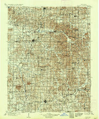
~ Ditney IN topo map, 1:125000 scale, 30 X 30 Minute, Historical, 1902, updated 1936
Ditney, Indiana, USGS topographic map dated 1902.
Includes geographic coordinates (latitude and longitude). This topographic map is suitable for hiking, camping, and exploring, or framing it as a wall map.
Printed on-demand using high resolution imagery, on heavy weight and acid free paper, or alternatively on a variety of synthetic materials.
Topos available on paper, Waterproof, Poly, or Tyvek. Usually shipping rolled, unless combined with other folded maps in one order.
- Product Number: USGS-5289214
- Free digital map download (high-resolution, GeoPDF): Ditney, Indiana (file size: 10 MB)
- Map Size: please refer to the dimensions of the GeoPDF map above
- Weight (paper map): ca. 55 grams
- Map Type: POD USGS Topographic Map
- Map Series: HTMC
- Map Verison: Historical
- Cell ID: 65361
- Scan ID: 156410
- Imprint Year: 1936
- Survey Year: 1902
- Datum: Unstated
- Map Projection: Polyconic
- Map published by United States Geological Survey
- Map Language: English
- Scanner Resolution: 600 dpi
- Map Cell Name: Ditney
- Grid size: 30 X 30 Minute
- Date on map: 1902
- Map Scale: 1:125000
- Geographical region: Indiana, United States
Neighboring Maps:
All neighboring USGS topo maps are available for sale online at a variety of scales.
Spatial coverage:
Topo map Ditney, Indiana, covers the geographical area associated the following places:
- Ayrshire - Alford - Millersport - Arthur - Greenbrier - Baugh City - Scottsburg - Tennyson - Whiteoak - Gudgel - Wheatonville - Fritz Corner - Bowman - Lynnville - Ashby Yards - Chandler - Stanley - Elliott - Otwell - Rolling Acres - Rosebud - Selvin - Dickeyville - Jockey - Wheeling - Willisville - Rockport Junction - Francisco - Cato - Oakland City - Dongola - Marysville - Daylight - Glezen - Velpen - Bloomfield - Survant - Folsomville - Center - Hartwell - Gray Junction - Boonville - Elberfeld - Turpin Hill - Pigeon - Buckskin - Stevenson - Muren - Oakland City Junction - Littles - Jarretts - Mount Olympus - Spurgeon - Millersburg - Stendal - Kercheval - Hartwell Junction - Coats Spring - De Gonia Springs - Graham Valley - Augusta - Chandler - Enos Corner - Zoar - Hemenway - Duff - Coe - Oatsville - Scalesville - Somerville - White Sulphur Springs - Ash Iron Springs - Pikeville - West Petersburg - Eames - Algiers - Saint John - Campbelltown - Petersburg - Holland - Winslow - Rumble - Fisherville - Heilman - Union - Chrisney - Gentryville - Loafers Station - Mackey - Oak Hill - Castle Garden - Eby
- Map Area ID: AREA38.538-87.5-87
- Northwest corner Lat/Long code: USGSNW38.5-87.5
- Northeast corner Lat/Long code: USGSNE38.5-87
- Southwest corner Lat/Long code: USGSSW38-87.5
- Southeast corner Lat/Long code: USGSSE38-87
- Northern map edge Latitude: 38.5
- Southern map edge Latitude: 38
- Western map edge Longitude: -87.5
- Eastern map edge Longitude: -87


