
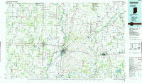
~ Vincennes IN topo map, 1:100000 scale, 30 X 60 Minute, Historical, 1986, updated 1986
Vincennes, Indiana, USGS topographic map dated 1986.
Includes geographic coordinates (latitude and longitude). This topographic map is suitable for hiking, camping, and exploring, or framing it as a wall map.
Printed on-demand using high resolution imagery, on heavy weight and acid free paper, or alternatively on a variety of synthetic materials.
Topos available on paper, Waterproof, Poly, or Tyvek. Usually shipping rolled, unless combined with other folded maps in one order.
- Product Number: USGS-5289204
- Free digital map download (high-resolution, GeoPDF): Vincennes, Indiana (file size: 17 MB)
- Map Size: please refer to the dimensions of the GeoPDF map above
- Weight (paper map): ca. 55 grams
- Map Type: POD USGS Topographic Map
- Map Series: HTMC
- Map Verison: Historical
- Cell ID: 72207
- Scan ID: 156180
- Imprint Year: 1986
- Woodland Tint: Yes
- Aerial Photo Year: 1984
- Edit Year: 1986
- Datum: NAD27
- Map Projection: Universal Transverse Mercator
- Planimetric: Yes
- Map published by United States Geological Survey
- Map Language: English
- Scanner Resolution: 600 dpi
- Map Cell Name: Vincennes
- Grid size: 30 X 60 Minute
- Date on map: 1986
- Map Scale: 1:100000
- Geographical region: Indiana, United States
Neighboring Maps:
All neighboring USGS topo maps are available for sale online at a variety of scales.
Spatial coverage:
Topo map Vincennes, Indiana, covers the geographical area associated the following places:
- Marco - Saint Thomas - Bartons Location - Emison - Johnstown - New Hebron - Oil Grove - Grisold (historical) - Davy - Busseron - Ridgleville - Pond Creek Mills - Wagner Station - Elnora - Crawfordsville (historical) - Stalcup Corner - Oil Center - Chauncey - Bucktown - Heathsville - Iva - Green Brier - Bruceville - Giro - Ilene - Sand Barrens - Westport - Sumner - Edwardsport - Bloods Wood Crossing - Graham - Pierceburg - Richwoods - Wheatland - Highbank Town - Villas - Bushrod - Pennyville - Sandborn - Plainville - Applegate - Black Oak - Decker - Five Points - Stringtown - Flat Rock - Lyons - Hardinville - Cornettsville - Adams Corner - Arda - Sisson - Vincennes - Landes - Montgomery - Carlisle - Westport - Purcell - Monroe City - Birds - Cumback - Amity - Twin Bridges - Lawrenceville - Petrolia - Cantaloupe - South Washington - Orio - Lancaster - Iona - Beal - Claremont - Beehunter - Capehart - Duncanville - Jackson - Indian Creek Settlement - Grays Corner - Thomas - Washington - Epsom - Maysville - Glendale - Lettsville - Saint Francisville - Jordan - Charlottsville (historical) - Pinkstaff - Bridgeport - Berryville - Oaktown - Corning - Russellville - Pleasantville - Bandmill - Freelandville - Hudsonville - Helena - Newberry - Verne
- Map Area ID: AREA3938.5-88-87
- Northwest corner Lat/Long code: USGSNW39-88
- Northeast corner Lat/Long code: USGSNE39-87
- Southwest corner Lat/Long code: USGSSW38.5-88
- Southeast corner Lat/Long code: USGSSE38.5-87
- Northern map edge Latitude: 39
- Southern map edge Latitude: 38.5
- Western map edge Longitude: -88
- Eastern map edge Longitude: -87


