
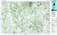
~ Terre Haute IN topo map, 1:100000 scale, 30 X 60 Minute, Historical, 1986, updated 1989
Terre Haute, Indiana, USGS topographic map dated 1986.
Includes geographic coordinates (latitude and longitude). This topographic map is suitable for hiking, camping, and exploring, or framing it as a wall map.
Printed on-demand using high resolution imagery, on heavy weight and acid free paper, or alternatively on a variety of synthetic materials.
Topos available on paper, Waterproof, Poly, or Tyvek. Usually shipping rolled, unless combined with other folded maps in one order.
- Product Number: USGS-5289202
- Free digital map download (high-resolution, GeoPDF): Terre Haute, Indiana (file size: 24 MB)
- Map Size: please refer to the dimensions of the GeoPDF map above
- Weight (paper map): ca. 55 grams
- Map Type: POD USGS Topographic Map
- Map Series: HTMC
- Map Verison: Historical
- Cell ID: 68447
- Scan ID: 156150
- Imprint Year: 1989
- Woodland Tint: Yes
- Photo Revision Year: 1986
- Aerial Photo Year: 1984
- Edit Year: 1986
- Datum: NAD27
- Map Projection: Universal Transverse Mercator
- Map published by United States Geological Survey
- Map Language: English
- Scanner Resolution: 600 dpi
- Map Cell Name: Terre Haute
- Grid size: 30 X 60 Minute
- Date on map: 1986
- Map Scale: 1:100000
- Geographical region: Indiana, United States
Neighboring Maps:
All neighboring USGS topo maps are available for sale online at a variety of scales.
Spatial coverage:
Topo map Terre Haute, Indiana, covers the geographical area associated the following places:
- Weir - Martinsville - Johnstown - Island City - Vicksburg - Brown Jug Corner - Curryville - Graysville - Taylorville - New Brunswick - Gospel Grove - Smithville - Old Hill - Switz City - Toad Hop - Jasonville - Benefiel Corner - Riley - Trimble - Barrick Corner - Gilmour - Blackhawk - Larimer Hill - Standard - Hickory Corner - Baldridge - Liggett - Linton - Youngstown - Glen Ayre - Dodds Bridge - Swalls - Hubbell - Buchanan Corner - Stearleyville - Darwin - Cleone - Hymera - Art - Palestine - Caledonia (historical) - Coalmont - Redcuff Corner - Walnut Prairie - Wilfred - Danville - Farrington - Adenmoor - Oak Point - Weaver - Merom Station - Hogue Town - Brunswick - Bogle Corner - Doyles - Hoosierville - Lone Tree - Prairieton - Cumberland - Whitcomb Heights - Prairie Creek - Asherville - Roadman Corner - Robinson - Choctaw - Clarksville - Oakcrest - Cass - Fairbanks - Fox Run - Bellair - Massacre - McKeen - Sponsler - Clay City - Porterville - Moriah - Daggett - Snyder - Hawton - White Rose - Turner - Allright - Jericho - Scott City - Paxton - Glen Ayre - Lewis - Oliver - Patton - East Shelburn - Midland - Saline City - Southwood - Summit - Spring Hill - Victoria - Casey - Ellis - Gambill
- Map Area ID: AREA39.539-88-87
- Northwest corner Lat/Long code: USGSNW39.5-88
- Northeast corner Lat/Long code: USGSNE39.5-87
- Southwest corner Lat/Long code: USGSSW39-88
- Southeast corner Lat/Long code: USGSSE39-87
- Northern map edge Latitude: 39.5
- Southern map edge Latitude: 39
- Western map edge Longitude: -88
- Eastern map edge Longitude: -87


