
~ South Bend IN topo map, 1:100000 scale, 30 X 60 Minute, Historical, 1983, updated 1984
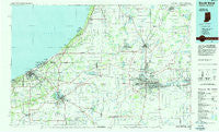
South Bend, Indiana, USGS topographic map dated 1983.
Includes geographic coordinates (latitude and longitude). This topographic map is suitable for hiking, camping, and exploring, or framing it as a wall map.
Printed on-demand using high resolution imagery, on heavy weight and acid free paper, or alternatively on a variety of synthetic materials.
Topos available on paper, Waterproof, Poly, or Tyvek. Usually shipping rolled, unless combined with other folded maps in one order.
- Product Number: USGS-5289194
- Free digital map download (high-resolution, GeoPDF): South Bend, Indiana (file size: 18 MB)
- Map Size: please refer to the dimensions of the GeoPDF map above
- Weight (paper map): ca. 55 grams
- Map Type: POD USGS Topographic Map
- Map Series: HTMC
- Map Verison: Historical
- Cell ID: 68389
- Scan ID: 160949
- Imprint Year: 1984
- Woodland Tint: Yes
- Aerial Photo Year: 1980
- Edit Year: 1983
- Datum: NAD27
- Map Projection: Universal Transverse Mercator
- Planimetric: Yes
- Map published by United States Geological Survey
- Map Language: English
- Scanner Resolution: 600 dpi
- Map Cell Name: South Bend
- Grid size: 30 X 60 Minute
- Date on map: 1983
- Map Scale: 1:100000
- Geographical region: Indiana, United States
Neighboring Maps:
All neighboring USGS topo maps are available for sale online at a variety of scales.
Spatial coverage:
Topo map South Bend, Indiana, covers the geographical area associated the following places:
- Springville - Baroda Estates - Eagle Lake Estates - North Liberty - Duneland Beach - Arden - Grand Beach - Sokol Camp - Merrick - Jerico - Galien - Ambler - Pinola - Berrien Center - Springfield - Judy's Mobile Home Court - LaPorte - Hi-View Addition - Glendora - Hesston - Hamlet - Dayton - Michiana - Smith - Granger - Berrien Springs - Woodland - Three Oaks - Bethany Beach - Kankakee - Miami Trails Addition - Westville - Oakview Estates Mobile Home Park - Hicks - Tamarack Grange - Niles - Rolling Prairie - Edwardsburg Mobile Home Estates - Buchanan - Rosemary Beach - Door Village - Shawnee Mobile Home Court - Lakewood Mobile Home Estates - Edwardsburg - New Troy - Kingsbury - Coburg - North Niles - Birchwood - Birchim - Tower Hill Shorelands - Pokagon - Midway Corners - Alida - Beverly Hill - Wakarusa - Silverbrook Manufactured Home Community - Lalimere - Long Beach - Sawyer - Oakwood - Plainfield - Bakertown - New Buffalo - Hinchman - Gilmer Park - Jamestown - Cassopolis - Ontario Place Mobile Home Park - Dailey - Chain-O-Lakes - Byron - Durham - Pennellwood - Westfield - Pleasant Valley - Davis - Marlin Village Mobile Home Community - Hubbard - Andry - Pine Station - Niles Pines Mobile Estates - Baroda - Gulivoire Park - Crest Manor Addition - Holmesville - River Spring Estates - South Bend - Otis - Orchard Heights Addition - Fairland - Hazelhurst - Harbert - Bertrand - New Carlisle - Nutwood - Crumstown - Warren Dunes Estates Mobile Home Park - Hudson Lake - Osceola
- Map Area ID: AREA4241.5-87-86
- Northwest corner Lat/Long code: USGSNW42-87
- Northeast corner Lat/Long code: USGSNE42-86
- Southwest corner Lat/Long code: USGSSW41.5-87
- Southeast corner Lat/Long code: USGSSE41.5-86
- Northern map edge Latitude: 42
- Southern map edge Latitude: 41.5
- Western map edge Longitude: -87
- Eastern map edge Longitude: -86


