
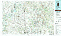
~ Princeton IN topo map, 1:100000 scale, 30 X 60 Minute, Historical, 1986, updated 1989
Princeton, Indiana, USGS topographic map dated 1986.
Includes geographic coordinates (latitude and longitude). This topographic map is suitable for hiking, camping, and exploring, or framing it as a wall map.
Printed on-demand using high resolution imagery, on heavy weight and acid free paper, or alternatively on a variety of synthetic materials.
Topos available on paper, Waterproof, Poly, or Tyvek. Usually shipping rolled, unless combined with other folded maps in one order.
- Product Number: USGS-5289190
- Free digital map download (high-resolution, GeoPDF): Princeton, Indiana (file size: 21 MB)
- Map Size: please refer to the dimensions of the GeoPDF map above
- Weight (paper map): ca. 55 grams
- Map Type: POD USGS Topographic Map
- Map Series: HTMC
- Map Verison: Historical
- Cell ID: 68194
- Scan ID: 159377
- Imprint Year: 1989
- Woodland Tint: Yes
- Aerial Photo Year: 1984
- Edit Year: 1986
- Datum: NAD27
- Map Projection: Universal Transverse Mercator
- Map published by United States Geological Survey
- Map Language: English
- Scanner Resolution: 600 dpi
- Map Cell Name: Princeton
- Grid size: 30 X 60 Minute
- Date on map: 1986
- Map Scale: 1:100000
- Geographical region: Indiana, United States
Neighboring Maps:
All neighboring USGS topo maps are available for sale online at a variety of scales.
Spatial coverage:
Topo map Princeton, Indiana, covers the geographical area associated the following places:
- Wheatonville - Saint Joseph - Douglas - Stewartsville - Selma (historical) - Princeton - Stevenson - Cowling - Pikeville - Martin - Hazleton - Turpin Hill - Odgen - Duff - Willisville - Hillsdale - Hartwell - Maud - Daylight - Castle Garden - Gray Junction - Mounts - Saint James - Somerville - Egg Harbor - Whiteoak - Union - Holland - King - Fort Branch - Keensburg - Greenbrier - Coe - New Baltimore - Fritz Corner - Arthur - Elliott - Gentryville - Blairsville - Oliver - Warrenton - Cherry Hill Estates - Darmstadt - Millersport - Grayville - Ashby Yards - Pohaten (historical) - Bone Gap - Solitude - Jockey - Johnson - Dongola - Owensville - Selvin - Heilman - West Petersburg - Boonville - Lyles - Lippe - Parkers Settlement - Gudgel - Ayrshire - McGary - Hartwell Junction - Cynthiana - Mount Olympus - Alford - Little Rock - Bloomfield - Jimtown - Durham - Schrodts Station - Oakland City Junction - Oak Hill - Highland - Loafers Station - McCutchanville - Kratzville - Petersburg - Augusta - Scalesville - Lexington (historical) - Glezen - Skelton - Pigeon - Lakewood Hills - Armstrong - Zoar - Orrville - Enos Corner - Bellmont - New Harmony - Spurgeon - Center - Saint John - Lynnville - Dickeyville - Mackey - Coats Spring - Barrett
- Map Area ID: AREA38.538-88-87
- Northwest corner Lat/Long code: USGSNW38.5-88
- Northeast corner Lat/Long code: USGSNE38.5-87
- Southwest corner Lat/Long code: USGSSW38-88
- Southeast corner Lat/Long code: USGSSE38-87
- Northern map edge Latitude: 38.5
- Southern map edge Latitude: 38
- Western map edge Longitude: -88
- Eastern map edge Longitude: -87


