
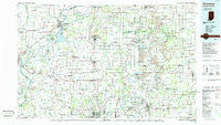
~ Princeton IN topo map, 1:100000 scale, 30 X 60 Minute, Historical, 1986, updated 1986
Princeton, Indiana, USGS topographic map dated 1986.
Includes geographic coordinates (latitude and longitude). This topographic map is suitable for hiking, camping, and exploring, or framing it as a wall map.
Printed on-demand using high resolution imagery, on heavy weight and acid free paper, or alternatively on a variety of synthetic materials.
Topos available on paper, Waterproof, Poly, or Tyvek. Usually shipping rolled, unless combined with other folded maps in one order.
- Product Number: USGS-5289188
- Free digital map download (high-resolution, GeoPDF): Princeton, Indiana (file size: 18 MB)
- Map Size: please refer to the dimensions of the GeoPDF map above
- Weight (paper map): ca. 55 grams
- Map Type: POD USGS Topographic Map
- Map Series: HTMC
- Map Verison: Historical
- Cell ID: 68194
- Scan ID: 159376
- Imprint Year: 1986
- Woodland Tint: Yes
- Aerial Photo Year: 1984
- Edit Year: 1986
- Datum: NAD27
- Map Projection: Universal Transverse Mercator
- Planimetric: Yes
- Map published by United States Geological Survey
- Map Language: English
- Scanner Resolution: 600 dpi
- Map Cell Name: Princeton
- Grid size: 30 X 60 Minute
- Date on map: 1986
- Map Scale: 1:100000
- Geographical region: Indiana, United States
Neighboring Maps:
All neighboring USGS topo maps are available for sale online at a variety of scales.
Spatial coverage:
Topo map Princeton, Indiana, covers the geographical area associated the following places:
- Blairsville - Winslow - Darmstadt - Lynnville - Springfield - Buckskin - Saint John - Muren - Wheatonville - Holland - Solitude - Griffin - Folsomville - Graham Valley - King - Eames - Chandler - Bellmont - Grayville - Oliver - New Harmony - Lakewood Hills - Rochester - Durham - Earle - Stringtown - New Baltimore - Dickeyville - Duff - Wheeling - Inglefield - Otwell - Saint Joseph - Stanley - Scalesville - Mechanicsville - Bowman - Mount Olympus - Greenbrier - Elberfeld - Castle Garden - Center - Gards Point - Bloomfield - Fort Branch - Tennyson - Stewartsville - Chrisney - Mackey - Eby - McGary - Douglas - Elliott - Coe - Velpen - Wadesville - Haubstadt - Baldwin Heights - Millersburg - Oakland City - Knob Hill - Rapture - Marysville - Gray Junction - Ayrshire - Patton - Country Club Meadows - Melody Hill - Heilman - East Mount Carmel - Union - Parkers Settlement - Dongola - Hemenway - Algiers - Crawleyville - Fritz Corner - Kercheval - Nisbet - Grafton - Owensville - Little Rock - Hillsdale - Zoar - Fisherville - Kasson - Coats Spring - Gentryville - Millersport - Hazleton - Survant - Erskine Station - Selma (historical) - Savah - McCutchanville - Fort Gibson (historical) - Mount Carmel - Princeton - De Gonia Springs - Selvin
- Map Area ID: AREA38.538-88-87
- Northwest corner Lat/Long code: USGSNW38.5-88
- Northeast corner Lat/Long code: USGSNE38.5-87
- Southwest corner Lat/Long code: USGSSW38-88
- Southeast corner Lat/Long code: USGSSE38-87
- Northern map edge Latitude: 38.5
- Southern map edge Latitude: 38
- Western map edge Longitude: -88
- Eastern map edge Longitude: -87


