
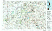
~ Knox IN topo map, 1:100000 scale, 30 X 60 Minute, Historical, 1984, updated 1994
Knox, Indiana, USGS topographic map dated 1984.
Includes geographic coordinates (latitude and longitude). This topographic map is suitable for hiking, camping, and exploring, or framing it as a wall map.
Printed on-demand using high resolution imagery, on heavy weight and acid free paper, or alternatively on a variety of synthetic materials.
Topos available on paper, Waterproof, Poly, or Tyvek. Usually shipping rolled, unless combined with other folded maps in one order.
- Product Number: USGS-5289164
- Free digital map download (high-resolution, GeoPDF): Knox, Indiana (file size: 20 MB)
- Map Size: please refer to the dimensions of the GeoPDF map above
- Weight (paper map): ca. 55 grams
- Map Type: POD USGS Topographic Map
- Map Series: HTMC
- Map Verison: Historical
- Cell ID: 67774
- Scan ID: 159993
- Imprint Year: 1994
- Woodland Tint: Yes
- Photo Inspection Year: 1991
- Aerial Photo Year: 1980
- Edit Year: 1984
- Datum: NAD27
- Map Projection: Universal Transverse Mercator
- Map published by United States Geological Survey
- Map Language: English
- Scanner Resolution: 600 dpi
- Map Cell Name: Knox
- Grid size: 30 X 60 Minute
- Date on map: 1984
- Map Scale: 1:100000
- Geographical region: Indiana, United States
Neighboring Maps:
All neighboring USGS topo maps are available for sale online at a variety of scales.
Spatial coverage:
Topo map Knox, Indiana, covers the geographical area associated the following places:
- Tefft - Maxinkuckee - Ora - Haskell - Lomax - Carmel (historical) - Ober - Mentone - English Lake - North Judson - Aldine - Kingsford Heights - Knox - Clanricarde - La Crosse - Dunns Bridge - Ripley - Culver - Plymouth - Walkerton - Linkville - South Wanatah - Medaryville - Indian Hill - Nappanee - Pershing - Vanmeter Park - Tracy - Donaldson - La Paz - Thomaston - Union Mills - Toto - Rochester - Bourbon - Etna Green - Koontz Lake - Walnut - La Paz Junction - Riverside - Inwood - Bruce Lake Station - Burr Oak - Union Center - Tiosa - Mount Zion - San Pierre - Baileys Corner - Delong - Argos - Athens - Wellsboro - Rutland - Wanatah - Locke - Runnymede - Teegarden - Harris - Tyner - Talma - Lowman Corner - Guise Park - Old Tip Town - Beaver Dam - Big Hill - Grovertown - Monterey - Tippecanoe - Akron - Denham - South Center - Brems - Bremen - Lena Park - Sevastopol - Leiters Ford - Richland Center - Summit Chapel - Bass Lake - Beardstown - Radioville - Kewanna - Wilders - Clarks - Bass Station - Oak Grove - Lake Bruce - Winamac - Winona - Twin Lakes - Asphaltum - Hanna - Lawton
- Map Area ID: AREA41.541-87-86
- Northwest corner Lat/Long code: USGSNW41.5-87
- Northeast corner Lat/Long code: USGSNE41.5-86
- Southwest corner Lat/Long code: USGSSW41-87
- Southeast corner Lat/Long code: USGSSE41-86
- Northern map edge Latitude: 41.5
- Southern map edge Latitude: 41
- Western map edge Longitude: -87
- Eastern map edge Longitude: -86


