
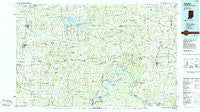
~ Jasper IN topo map, 1:100000 scale, 30 X 60 Minute, Historical, 1986, updated 1986
Jasper, Indiana, USGS topographic map dated 1986.
Includes geographic coordinates (latitude and longitude). This topographic map is suitable for hiking, camping, and exploring, or framing it as a wall map.
Printed on-demand using high resolution imagery, on heavy weight and acid free paper, or alternatively on a variety of synthetic materials.
Topos available on paper, Waterproof, Poly, or Tyvek. Usually shipping rolled, unless combined with other folded maps in one order.
- Product Number: USGS-5289158
- Free digital map download (high-resolution, GeoPDF): Jasper, Indiana (file size: 17 MB)
- Map Size: please refer to the dimensions of the GeoPDF map above
- Weight (paper map): ca. 55 grams
- Map Type: POD USGS Topographic Map
- Map Series: HTMC
- Map Verison: Historical
- Cell ID: 67731
- Scan ID: 159975
- Imprint Year: 1986
- Woodland Tint: Yes
- Aerial Photo Year: 1983
- Edit Year: 1986
- Datum: NAD27
- Map Projection: Universal Transverse Mercator
- Planimetric: Yes
- Map published by United States Geological Survey
- Map Language: English
- Scanner Resolution: 600 dpi
- Map Cell Name: Jasper
- Grid size: 30 X 60 Minute
- Date on map: 1986
- Map Scale: 1:100000
- Geographical region: Indiana, United States
Neighboring Maps:
All neighboring USGS topo maps are available for sale online at a variety of scales.
Spatial coverage:
Topo map Jasper, Indiana, covers the geographical area associated the following places:
- Artist Point - Oolite - Beechland - Liberal - Crandall - Adyeville - Martinsburg - Maltersville - Sassafras - Schnellville - Mooleyville - Mauckport - Little Saint Louis - Schooler Point Landing - Bretzville - Santa Fe - Carefree - Old Pekin - Pine Valley - Clay City - Newton Stewart - Palmyra - Kyana - Birdseye - Apalona - Bristow - English - Ranger - Rehoboth - Saint Croix - Dubois Crossroads - New Boston - Greenbrier - Chenaultt - Andyville - Lodale - Fredericksburg - Fredonia - Maxville - White Cloud - Moberly - Mott Station - Riddle - Evanston - Leavenworth - Corydon - New Salisbury - Mentor - Lilly Dale - Wolf Creek - Hancock Chapel - Jericho - Ireland - Frenchtown - Rhodelia - Curby - Taswell - Terry - Magnolia - Portersville - Temple - Depauw - Pilot Knob - Organ Springs - Roberta - Switzer Crossroads - Hillcrest - Gerald - Lincoln City - Byrneville - Ramsey - Deuchars - Dale - Santa Claus - Rego - Wickliffe - Mariah Hill - Saint Marks - Saint Meinrad - Morvins Landing - Celina - Dogwood - New Middletown - Valley City - Hardinsburg - Dubois - Wyandotte - Celestine - Breckenridge - West Hill - Brownstown - Hogtown - Valeene - Peckenpaugh (historical) - Fosters Ridge - Doolittle Mills - Magnet - Newtonville - Norton - Fayetteville
- Map Area ID: AREA38.538-87-86
- Northwest corner Lat/Long code: USGSNW38.5-87
- Northeast corner Lat/Long code: USGSNE38.5-86
- Southwest corner Lat/Long code: USGSSW38-87
- Southeast corner Lat/Long code: USGSSE38-86
- Northern map edge Latitude: 38.5
- Southern map edge Latitude: 38
- Western map edge Longitude: -87
- Eastern map edge Longitude: -86


