
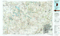
~ Fort Wayne IN topo map, 1:100000 scale, 30 X 60 Minute, Historical, 1994, updated 1994
Fort Wayne, Indiana, USGS topographic map dated 1994.
Includes geographic coordinates (latitude and longitude). This topographic map is suitable for hiking, camping, and exploring, or framing it as a wall map.
Printed on-demand using high resolution imagery, on heavy weight and acid free paper, or alternatively on a variety of synthetic materials.
Topos available on paper, Waterproof, Poly, or Tyvek. Usually shipping rolled, unless combined with other folded maps in one order.
- Product Number: USGS-5289148
- Free digital map download (high-resolution, GeoPDF): Fort Wayne, Indiana (file size: 26 MB)
- Map Size: please refer to the dimensions of the GeoPDF map above
- Weight (paper map): ca. 55 grams
- Map Type: POD USGS Topographic Map
- Map Series: HTMC
- Map Verison: Historical
- Cell ID: 67542
- Scan ID: 156850
- Imprint Year: 1994
- Woodland Tint: Yes
- Aerial Photo Year: 1988
- Edit Year: 1994
- Datum: NAD27
- Map Projection: Universal Transverse Mercator
- Map published by United States Geological Survey
- Map Language: English
- Scanner Resolution: 600 dpi
- Map Cell Name: Fort Wayne
- Grid size: 30 X 60 Minute
- Date on map: 1994
- Map Scale: 1:100000
- Geographical region: Indiana, United States
Neighboring Maps:
All neighboring USGS topo maps are available for sale online at a variety of scales.
Spatial coverage:
Topo map Fort Wayne, Indiana, covers the geographical area associated the following places:
- Briggs - Clunette - Raber - Crestwood - Dunn Mill - Gravelton - Wa-Will-Away Park - Black Point - Levert - North Highland - Arrowhead Park - Leesburg - Larwill - Warsaw - Laotto - New Era - Brimfield - Corunna - Wooster - Hastings - Egans Point - Highbanks - Wayne Center - Fairfield Center - Country Club Gardens - Lake Shores - Ludwig Park - Hacienda Village - Musquabuck Park - Covington Dells - Bayfield - Aboite - Wilmot - Claypool - Ansley Acres - Eagle Point - Parkway Hills - Etna - Westlawn - Westchester - Monoquet - Meadowbrook - Northcrest - Manor Woods - Wakeville Village - Tanglewood - Leo - Cromwell - Wawasee Village - Quaker Haven Park - Stoneburner Landing - Highlands Park - Garrett - Churubusco - Saturn - Arcola - Auburn Junction - Port Mitchell - Cedar Point - Ellison - Indian Village - Forest Ridge - Royville - Cresco - Albion - Kalorama Park - Huntertown - Academie - Luther - Butler Center - Brierwood Hills - Avilla - Grismore - Concordia Gardens - Pickwick Park - Milford - Lisbon - Westmoor - Cedarville - Osborn Landing - Yellowbanks - Kanata Manayunk - Disko - North Webster - Cedar Canyons - Epworth Forest - Brookside Estates - Redmon Park - Atwood - Syracuse - Liberty Mills - Collins - Liberty Hills - Oswego - Lorane - Marineland Gardens - Wawasee - Swan - Stony Ridge - Timbercrest
- Map Area ID: AREA41.541-86-85
- Northwest corner Lat/Long code: USGSNW41.5-86
- Northeast corner Lat/Long code: USGSNE41.5-85
- Southwest corner Lat/Long code: USGSSW41-86
- Southeast corner Lat/Long code: USGSSE41-85
- Northern map edge Latitude: 41.5
- Southern map edge Latitude: 41
- Western map edge Longitude: -86
- Eastern map edge Longitude: -85


