
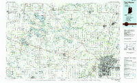
~ Fort Wayne IN topo map, 1:100000 scale, 30 X 60 Minute, Historical, 1984, updated 1985
Fort Wayne, Indiana, USGS topographic map dated 1984.
Includes geographic coordinates (latitude and longitude). This topographic map is suitable for hiking, camping, and exploring, or framing it as a wall map.
Printed on-demand using high resolution imagery, on heavy weight and acid free paper, or alternatively on a variety of synthetic materials.
Topos available on paper, Waterproof, Poly, or Tyvek. Usually shipping rolled, unless combined with other folded maps in one order.
- Product Number: USGS-5289146
- Free digital map download (high-resolution, GeoPDF): Fort Wayne, Indiana (file size: 18 MB)
- Map Size: please refer to the dimensions of the GeoPDF map above
- Weight (paper map): ca. 55 grams
- Map Type: POD USGS Topographic Map
- Map Series: HTMC
- Map Verison: Historical
- Cell ID: 67542
- Scan ID: 156849
- Imprint Year: 1985
- Woodland Tint: Yes
- Aerial Photo Year: 1981
- Edit Year: 1984
- Datum: NAD27
- Map Projection: Universal Transverse Mercator
- Planimetric: Yes
- Map published by United States Geological Survey
- Map Language: English
- Scanner Resolution: 600 dpi
- Map Cell Name: Fort Wayne
- Grid size: 30 X 60 Minute
- Date on map: 1984
- Map Scale: 1:100000
- Geographical region: Indiana, United States
Neighboring Maps:
All neighboring USGS topo maps are available for sale online at a variety of scales.
Spatial coverage:
Topo map Fort Wayne, Indiana, covers the geographical area associated the following places:
- Ligonier - Meadowbrook - Highbanks - Sunrise Beach - Egans Point - Tri-Lakes - Ellison - Cedarville - Avalon - Pierceton - Cedar - Ormas - Packerton - Brookside Estates - Arrowhead Park - Waynedale - Collins - Albion - Wallen - Royville - Island Park - Times Corner - North Manchester - Port Mitchell - Etna - Churubusco - Hastings - Corunna - Luther - Leo-Cedarville - Enchanted Hills - Wawaka - Auburn Junction - Cedar Canyons - Burr Oak - Cromwell - Burket - Fort Wayne - Palestine - Allen - Winona Lake - Stony Ridge - Sidney - Hacienda Village - Forest Glen - Concordia Gardens - Vawter Park - Sunnymede Woods - Buttermilk Point - Silver Lake - Wawasee - Cresco - Clunette - New Era - Leo - Grismore - Dunfee - Five Points - Warsaw - Bell Rohr Park - Bayfield - Covington Dells - Epworth Forest - Disko - Walnut Corners - Sedan - Saint Johns - South Whitley - Syracuse - Silver Point - Hillcrest - Lorane - Potawatomi Park - Leesburg - Kendallville - Laotto - Eagle Point - Thurman - Westlawn - Forest Ridge - Crestwood - Cedar Point - Peabody - Royal Oaks - Sunnymeadow - Kinsey - Kanata Manayunk - Eastland Gardens - Country Club Gardens - Swan - Wilmot - Saturn - Marineland Gardens - Dunn Mill - River Haven - Ellisville - Green Center - Kimmell - Academie - Washington Center
- Map Area ID: AREA41.541-86-85
- Northwest corner Lat/Long code: USGSNW41.5-86
- Northeast corner Lat/Long code: USGSNE41.5-85
- Southwest corner Lat/Long code: USGSSW41-86
- Southeast corner Lat/Long code: USGSSE41-85
- Northern map edge Latitude: 41.5
- Southern map edge Latitude: 41
- Western map edge Longitude: -86
- Eastern map edge Longitude: -85


