
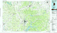
~ Bloomington IN topo map, 1:100000 scale, 30 X 60 Minute, Historical, 1986, updated 1986
Bloomington, Indiana, USGS topographic map dated 1986.
Includes geographic coordinates (latitude and longitude). This topographic map is suitable for hiking, camping, and exploring, or framing it as a wall map.
Printed on-demand using high resolution imagery, on heavy weight and acid free paper, or alternatively on a variety of synthetic materials.
Topos available on paper, Waterproof, Poly, or Tyvek. Usually shipping rolled, unless combined with other folded maps in one order.
- Product Number: USGS-5289134
- Free digital map download (high-resolution, GeoPDF): Bloomington, Indiana (file size: 20 MB)
- Map Size: please refer to the dimensions of the GeoPDF map above
- Weight (paper map): ca. 55 grams
- Map Type: POD USGS Topographic Map
- Map Series: HTMC
- Map Verison: Historical
- Cell ID: 67153
- Scan ID: 156695
- Imprint Year: 1986
- Woodland Tint: Yes
- Aerial Photo Year: 1984
- Edit Year: 1986
- Datum: NAD27
- Map Projection: Universal Transverse Mercator
- Planimetric: Yes
- Map published by United States Geological Survey
- Map Language: English
- Scanner Resolution: 600 dpi
- Map Cell Name: Bloomington
- Grid size: 30 X 60 Minute
- Date on map: 1986
- Map Scale: 1:100000
- Geographical region: Indiana, United States
Neighboring Maps:
All neighboring USGS topo maps are available for sale online at a variety of scales.
Spatial coverage:
Topo map Bloomington, Indiana, covers the geographical area associated the following places:
- Handy - Calvertville - Raab Crossroads - Fleener - Patricksburg - Peoga - Mount Healthy - Whitaker - New Hope - Stone Head - Plano - Wooded Hills Mobile Home Park - Mahalasville - Beamer - Hoosier Acres - Waymansville - West Overlook - Youno (historical) - Newark - Mount Liberty - Arney - Freeman - West Brook Downs - Wolff - Elliston - Nashville - Hindustan - Point Commerce - Silex - Ellettsville - Nineveh - Ridgeport - Woodcrest - Houston - Annandale Estates - Forest Park Heights - Six Points - Taggart Crossing - Painted Hills - Bear Wallow - Cataract - Lanam - Champlin Meadows - Hopewell - Ogilville - Pottersville - Morgantown - Elwren - Marion Mills - Grandview Lake - Leonard Springs - Elkinsville - Van Buren Park - Hancock Corner - Fewell Rhoades - Bald Knobs - Stratford (historical) - Adams - Laveianan Court - Hashtown - Prather - Marlin Hills - Clear Creek - Highland Village - Spraytown - Gatesville - Buffalo (historical) - Wakeland - Trafalgar - Sanders - Tulip - Taggart - Cunot - Wallace Junction - Buenavista - Stony Lonesome - Furnace - Alaska - Hickman's Trailer Park - Turkey Track - New Unionville - Story - Cincinnati - Broadview - Christiansburg - Potato Mound - Paragon - Adel - Cope - Solsberry - Woodville Hills - Carp - Trevlac - Camp Roberts - Beanblossom - Spencer - Highets Corner - Martinsville - Arlington - North Ogilville
- Map Area ID: AREA39.539-87-86
- Northwest corner Lat/Long code: USGSNW39.5-87
- Northeast corner Lat/Long code: USGSNE39.5-86
- Southwest corner Lat/Long code: USGSSW39-87
- Southeast corner Lat/Long code: USGSSE39-86
- Northern map edge Latitude: 39.5
- Southern map edge Latitude: 39
- Western map edge Longitude: -87
- Eastern map edge Longitude: -86


