
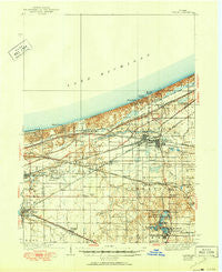
~ Porter IN topo map, 1:62500 scale, 15 X 15 Minute, Historical, 1940, updated 1950
Porter, Indiana, USGS topographic map dated 1940.
Includes geographic coordinates (latitude and longitude). This topographic map is suitable for hiking, camping, and exploring, or framing it as a wall map.
Printed on-demand using high resolution imagery, on heavy weight and acid free paper, or alternatively on a variety of synthetic materials.
Topos available on paper, Waterproof, Poly, or Tyvek. Usually shipping rolled, unless combined with other folded maps in one order.
- Product Number: USGS-5289062
- Free digital map download (high-resolution, GeoPDF): Porter, Indiana (file size: 6 MB)
- Map Size: please refer to the dimensions of the GeoPDF map above
- Weight (paper map): ca. 55 grams
- Map Type: POD USGS Topographic Map
- Map Series: HTMC
- Map Verison: Historical
- Cell ID: 61220
- Scan ID: 160900
- Imprint Year: 1950
- Survey Year: 1934
- Datum: NAD27
- Map Projection: Polyconic
- Map published by United States Geological Survey
- Map Language: English
- Scanner Resolution: 600 dpi
- Map Cell Name: Porter
- Grid size: 15 X 15 Minute
- Date on map: 1940
- Map Scale: 1:62500
- Geographical region: Indiana, United States
Neighboring Maps:
All neighboring USGS topo maps are available for sale online at a variety of scales.
Spatial coverage:
Topo map Porter, Indiana, covers the geographical area associated the following places:
- Shady Side - Wheeler - Pleasant Valley - Meadowbrook - Furnessville - Dune Acres - Western Acres - Garyton - Edgewater - Marine Drive Mobile Home Park - Woodville - Morgan Park - Long Lake Island - Brummitt Acres - Crocker - Rainbow Mobile Home Park - Graham Woods - Babcock - McCool - Meadowview Mobile Home Park - South Haven - Woodland Village - Tremont - Lake Station - Wake Robin Fields - Tratebas Mill - Dons Mobile Home Park - Whispering Sands Mobile Home Court - Lake View - Burns Harbor - Salt Creek Estates - Roble Woods - Liberty Farm Mobile Home Park - Camelot Manor Estates - Northwood Park - Burlington Beach - Shadyside Mobile Home Court - Crisman - Chesterton - Dune Acres Station - Willow Creek - Blackhawk Beach - Portage - Hillcrest - Forest Oaks - Wilson - Suman - Haglund - Ogden Dunes - Porter
- Map Area ID: AREA41.7541.5-87.25-87
- Northwest corner Lat/Long code: USGSNW41.75-87.25
- Northeast corner Lat/Long code: USGSNE41.75-87
- Southwest corner Lat/Long code: USGSSW41.5-87.25
- Southeast corner Lat/Long code: USGSSE41.5-87
- Northern map edge Latitude: 41.75
- Southern map edge Latitude: 41.5
- Western map edge Longitude: -87.25
- Eastern map edge Longitude: -87


